Complete guides: •What Is Fauna?
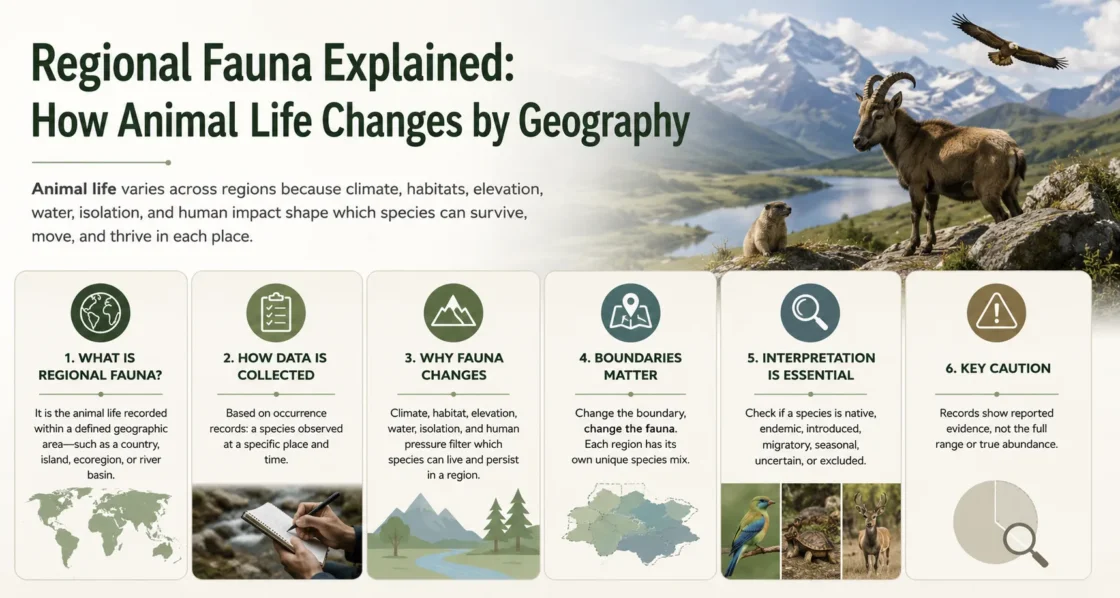
Regional fauna is the animal life associated with a defined geographic area. It changes from place to place because climate, elevation, water connections, habitat structure, physical barriers, evolutionary history, seasonal movement, and human transport determine which animals can reach a region, survive there, and maintain populations.
The word “region” does not refer to one fixed type of boundary. It may describe a continent, biogeographic realm, ecoregion, island, mountain zone, river basin, coastal shelf, protected area, country, or dataset polygon. Each boundary produces a different fauna list because it includes and excludes animals according to a different geographic rule.
Regional Fauna Begins with the Boundary
A list titled “fauna of a region” has little biological meaning until the region itself has been defined. Country borders are useful for wildlife law, national reporting, protected-species lists, and administrative management. They do not necessarily follow climate zones, watersheds, mountain systems, migration routes, or long-established divisions between animal communities.
Ecological boundaries answer different questions. An ecoregion groups landscapes with related environmental conditions and biological assemblages. A watershed follows the connected water system used by freshwater organisms. An island boundary emphasizes colonization, isolation, and establishment history. An elevation band separates climatic and habitat zones that may occur within the same mountain range.
| Geographic boundary | Biological question | Faunal pattern it can represent | Main blind spot |
|---|---|---|---|
| Country or province | Which animals are reported, managed, protected, or regulated within an administrative area? | National checklists, legal status, official surveys, and protected-area records. | Ecological communities and ranges may continue across the border. |
| Biogeographic realm | Which broad animal lineages share a long history of geographic separation? | Continental-scale differences in ancestry, colonization, and species composition. | Local habitats, small islands, and narrow transition zones are generalized. |
| Biome | Which animals are associated with a broad climate and vegetation formation? | Large patterns linked to tropical forest, desert, tundra, grassland, or other biome conditions. | Similar biomes on different continents may contain unrelated animal groups. |
| Ecoregion | Which animal assemblages occur within a more geographically distinct ecological unit? | Regional habitat associations, community differences, and conservation representation. | Fine-scale caves, wetlands, cliffs, urban areas, and local refuges may remain unresolved. |
| Watershed | Which aquatic animals are connected by the same drainage network? | Freshwater fish, mussels, aquatic insects, amphibians, and river-dependent species. | Adjacent basins may be close on land but disconnected for aquatic dispersal. |
| Island or archipelago | How have isolation, colonization, extinction, and introduction shaped the fauna? | Endemic lineages, restricted-range animals, seabird colonies, and introduced populations. | Marine species and wide-ranging migrants may not follow the shoreline boundary. |
| Elevation zone | How does fauna change as temperature, vegetation, moisture, and oxygen conditions change with height? | Montane species replacement, high-elevation endemism, and vertical migration. | Animals may move seasonally between zones or use different elevations during different life stages. |
| Marine province or ecoregion | Which coastal and shelf communities share oceanographic and evolutionary conditions? | Reef fish, coastal invertebrates, marine reptiles, seabirds, and shelf-associated mammals. | Pelagic, deep-sea, and highly migratory animals may cross several mapped units. |
Climate Filters Animals, but History Supplies the Lineages
Temperature, rainfall, season length, water availability, fire, snow cover, salinity, and vegetation structure limit the conditions an animal must tolerate. These environmental filters help explain why reptiles are constrained by cold conditions, why amphibian communities often track moisture, or why seasonal food cycles affect migratory and hibernating animals.
Climate alone does not determine regional fauna. Two places with similar temperatures and rainfall can support very different animals when their continents, islands, or drainage systems have separate evolutionary histories. A global analysis of more than 30,000 terrestrial tetrapod species found that both climatic conditions and the geographic arrangement of those climates help explain patterns of species richness and species replacement.[b]
Similar Climate Does Not Mean Identical Fauna
Suitable climate may allow an animal to survive, but the species must also have reached the region or evolved there. Oceans, deserts, mountain systems, past glaciation, plate movements, and older extinction events can leave comparable habitats with unrelated animal communities.
Modern zoogeographic research therefore compares both the species found in each area and their evolutionary relationships. A global vertebrate regionalization based on 21,037 amphibian, bird, and mammal species identified broad realms and smaller regions from patterns of taxonomic and phylogenetic turnover.[a] These divisions represent shared biological history rather than simple latitude bands.
Mountains Make Geography Vertical
Mountain fauna can change over distances that appear small on a horizontal map. Rising elevation alters temperature, frost exposure, atmospheric pressure, vegetation, soil moisture, stream conditions, and the length of the growing season. A lowland forest, cloud forest, shrub zone, alpine meadow, and bare summit may occur within one mountain system while supporting different animal assemblages.
The pattern is not always a simple decline in species numbers toward the summit. Some animal groups peak at middle elevations, some decline steadily, and others show replacement between narrow elevational zones. Mountain aspect, rainfall, habitat area, geological history, and connections to neighboring ranges can alter the pattern. Research on global mountain biodiversity links steep climatic gradients with rapid species turnover over short distances and with concentrations of small-ranged species.[c]
Mountains can also act in opposite ways at the same time. Valleys and passes may provide dispersal routes, while ridgelines, glaciers, dry slopes, and unsuitable high ground separate populations. An animal capable of crossing the barrier may retain a broad range; a less mobile or habitat-specialized animal may become restricted to one slope, valley, or elevation belt.
Barriers Create Turnover Between Neighboring Regions
Geographic distance is not the same as biological connectivity. Two sites separated by a short channel, dry valley, mountain crest, waterfall, salinity change, or unsuitable habitat may exchange fewer animals than two distant sites connected by continuous forest, coastline, river, or migration corridor.
Oceans and Island Isolation
Oceanic islands are reached by only a subset of mainland animals. Flying species, rafting organisms, marine dispersers, and animals carried by storms or people have different probabilities of arrival. Once isolated, populations may diverge from their source lineages. The resulting fauna may contain fewer broad animal groups than a continent while holding species found nowhere else.
Island size, age, elevation, distance from source populations, habitat diversity, storm frequency, and connections among islands all affect which animals become established. Human transport later adds another layer by moving predators, competitors, parasites, and prey across barriers that previously limited dispersal.
River Systems Connect Some Animals and Divide Others
A connected river network can function as a dispersal route for fish and other aquatic organisms. The surrounding dry land may prevent those same animals from reaching a neighboring basin. For terrestrial mammals, reptiles, or flightless invertebrates, a wide river may instead act as a barrier separating populations on opposite banks.
The biological effect therefore depends on the animal group. A river is habitat for one species, a corridor for another, a seasonal crossing point for a third, and an uncrossable boundary for another.
Drylands, Ice, and Habitat Gaps
Deserts, permanent ice, open agricultural land, urban development, and deforested belts can interrupt otherwise connected ranges. These barriers do not affect every species equally. Wide-ranging birds may cross them, while forest-floor amphibians, small mammals, land snails, or moisture-dependent arthropods may remain separated.
Land, Rivers, and Seas Require Different Regional Maps
Regional fauna cannot be represented by a single global boundary system. Terrestrial animals respond strongly to land climate, vegetation, soil, topography, and continental history. Freshwater animals follow drainage connections and basin history. Marine animals respond to water temperature, depth, currents, coastal form, seabed habitat, and oceanographic isolation.
The terrestrial ecoregion system used in global conservation divides land into 846 ecoregions distributed among 14 biomes.[d] Freshwater Ecoregions of the World was developed separately because fish and other freshwater processes create boundaries that terrestrial maps do not capture.[e] Marine Ecoregions of the World uses a nested system of realms, provinces, and ecoregions for coastal and continental-shelf waters.[f]
| Regional system | Geography that shapes the boundary | Animal groups most directly represented | Why another system cannot replace it |
|---|---|---|---|
| Terrestrial ecoregions | Land climate, vegetation, topography, soils, and continental biological history. | Land mammals, birds, reptiles, amphibians, insects, arachnids, land mollusks, and other terrestrial animals. | A land polygon may combine several disconnected river basins and does not describe marine circulation. |
| Freshwater ecoregions | Drainage basins, river connections, lake systems, waterfalls, basin capture, and aquatic history. | Freshwater fish, aquatic mollusks, crayfish, aquatic insects, amphibians, turtles, and crocodilians. | Adjacent land habitats may belong to one terrestrial unit while their rivers contain separate aquatic faunas. |
| Marine ecoregions | Water temperature, currents, depth, coastal form, shelf structure, upwelling, and ocean barriers. | Coastal fish, corals, crustaceans, mollusks, marine reptiles, seabirds, and shelf-associated mammals. | Country shorelines and terrestrial biomes do not describe underwater connectivity or oceanographic boundaries. |
One Faunal Map Cannot Represent Every Animal Group
Biogeographic boundaries depend partly on the animals being studied. Birds, amphibians, mammals, reptiles, freshwater fish, insects, and marine invertebrates differ in dispersal ability, habitat dependence, evolutionary age, and sensitivity to barriers. A line that separates amphibian communities may be weak for migratory birds. A mountain system that divides lowland mammals may contain connected populations of flying insects.
A 2024 global analysis of ant biogeography found regional patterns that were related to, but not identical with, regionalizations developed for tetrapods and vascular plants. The study also produced different broad divisions when ant genera and ant species were analyzed separately.[g] The result shows why a regional boundary should name its taxonomic scope rather than being presented as a universal division of all fauna.
The Boundary Depends on the Animals Included
A “regional fauna” covering all animals may combine patterns that do not share the same borders. Mammal regions, bird regions, ant regions, freshwater fish basins, and marine provinces should not be treated as interchangeable simply because they occupy the same map.
Species Richness and Species Replacement Describe Different Patterns
A region with more species is not automatically more distinct. Species richness records how many species occur within a defined area and taxonomic scope. Species turnover describes how strongly the species composition changes between areas.
Two regions may contain similar numbers of mammal or bird species while sharing few of the same species. Another pair may differ in richness but contain largely overlapping communities. Endemism adds a third pattern by identifying species restricted to a particular boundary.
- Species richness measures the number of species within the stated area and scope.
- Species turnover measures replacement in species composition between areas.
- Endemism describes restriction to the defined region or to a smaller area within it.
- Range overlap describes the portion of fauna shared between neighboring or connected regions.
- Phylogenetic turnover compares evolutionary relationships as well as species names.
These measures answer different questions. A tropical region may have high richness, an island may have strong endemism, and a narrow transition zone may show rapid turnover. None can be substituted for another without changing the biological meaning.
Regional Lists Change with Season, Establishment, and Taxonomy
A regional fauna is not always a year-round resident community. Migratory birds, bats, marine mammals, fish, insects, and sea turtles may use a region only during breeding, wintering, feeding, migration, or juvenile development. A seasonal visitor belongs to the documented fauna of that period but should not be described as permanently resident.
Establishment history also changes the list. Native animals reached or evolved in the region without human introduction. Endemic animals are restricted to the stated area. Introduced animals were moved beyond their native ranges through human activity. An introduced population may fail, remain casual, reproduce locally, become established, expand, or cause documented ecological harm. “Introduced” and “invasive” therefore describe different conditions.
Taxonomic revision can alter regional species totals without any immediate change in the animals present. A formerly widespread species may be divided into several species with smaller ranges. Several named forms may be merged. Older museum records may use synonyms or classifications no longer accepted by the selected taxonomic authority. A source-based fauna list needs a named taxonomy and release date when exact totals are reported.
Occurrence Records Show Evidence, Not Full Distribution
Regional fauna research often uses occurrence records from preserved specimens, field observations, monitoring programs, photographs, acoustic detections, literature, or machine observations. Darwin Core defines an occurrence as an event establishing the state of an organism at a particular place and time.[h]
That record can support a statement that reported evidence exists for the taxon at the recorded location and date. It does not by itself establish the animal’s full range, abundance, breeding status, native status, or continuous presence across the surrounding region.
Record density also reflects human activity. Accessible roads, cities, research stations, museums, protected areas, popular birding sites, and long-running monitoring projects often contain more records than remote or poorly surveyed places. GBIF has documented broad geographic and taxonomic sampling biases across available terrestrial and marine occurrence data.[i]
Record Gaps Are Not Automatic Absences
A blank area on an occurrence map may represent unsuitable habitat, true absence, limited access, missing digitization, weak survey effort, unresolved taxonomy, or records withheld for sensitive species. Regional presence and absence claims require more than a visual count of map points.
Human Movement Redraws Regional Fauna
Modern regional fauna includes biological patterns created by cities, roads, agriculture, shipping, aviation, canals, reservoirs, forestry, fisheries, the pet trade, and deliberate releases. These activities remove some habitats, divide others, create new feeding opportunities, and transport animals across former barriers.
Urban and agricultural regions may favor animals able to use buildings, artificial water, crops, refuse, disturbed ground, or fragmented habitat. Other species disappear locally when breeding sites, host species, migration corridors, or seasonal resources are lost. The resulting fauna may contain native survivors, seasonal visitors, introduced populations, domestic animals living outside captivity, and species expanding from neighboring regions.
Climate change can move suitable conditions while roads, coastlines, farms, dams, and cities restrict movement toward them. Regional fauna may therefore change through range expansion, range contraction, elevational movement, altered migration timing, local extinction, colonization, introduction, or taxonomic recognition. The date and evidence source are part of the geographic claim whenever a regional fauna is described.
Sources and Verification
- [a] Holt et al. — An Update of Wallace’s Zoogeographic Regions of the World — Used for the vertebrate-based global zoogeographic regionalization and its use of taxonomic and phylogenetic turnover.
- [b] Coelho et al. — The Geography of Climate and the Global Patterns of Species Diversity — Used for the relationship among climate, the geographic arrangement of climate, tetrapod richness, and species turnover.
- [c] Rahbek et al. — Humboldt’s Enigma: What Causes Global Patterns of Mountain Biodiversity? — Used for short-distance climatic gradients, mountain species turnover, and concentrations of restricted-range species.
- [d] Dinerstein et al. — An Ecoregion-Based Approach to Protecting Half the Terrestrial Realm — Used for the terrestrial system of 846 ecoregions distributed among 14 biomes.
- [e] WWF — Freshwater Ecoregions of the World — Used for freshwater regionalization based on aquatic species distributions, drainage systems, and freshwater processes.
- [f] Spalding et al. — Marine Ecoregions of the World — Used for the nested marine system of realms, provinces, and coastal or continental-shelf ecoregions.
- [g] Wang et al. — Global Biogeographic Regions for Ants Have Complex Relationships with Those for Plants and Tetrapods — Used for taxon-dependent regional boundaries and differences between genus-level and species-level ant regionalizations.
- [h] Biodiversity Information Standards — Darwin Core Quick Reference Guide — Used for the definition of an occurrence as evidence tied to an organism, place, and time.
- [i] GBIF — Sampling Biases Shape Our View of the Natural World — Used for geographic and taxonomic bias in available terrestrial and marine occurrence records.
Related Topics
- → Endemic Fauna Explained: Why Some Animals Live Only in One Region
- → Native Fauna Explained: Meaning and Examples
- → What Is Fauna? Meaning, Examples, and Scientific Use
- → Fauna vs Flora: Key Differences in Biology
- → How Scientists Classify Fauna by Region, Habitat, and Taxonomy
- → Aquatic Fauna Explained: Freshwater and Marine Animal Life