Complete guides: •What Is Fauna?
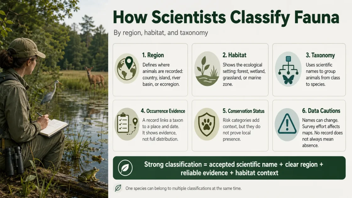
Scientists classify fauna along three separate but connected axes: the taxonomic identity of the animals, the geographic area in which they are recorded, and the habitats or ecological settings they use. These axes answer different questions. Taxonomy identifies the organism and its biological relationships; regional classification defines the spatial boundary of the fauna; habitat classification describes the environmental context associated with the animal or observation.
Fauna is not a formal taxonomic rank. Phrases such as “the mammal fauna of Madagascar,” “cave fauna,” and “Pleistocene marine fauna” describe assemblages of animal taxa selected by place, environment, time, or a combination of those limits. The animals within an assemblage still belong to their own species, genera, families, orders, and higher taxa.
The Three Classifications Describe Different Properties
Only taxonomic classification organizes animals according to biological relationships. Regional and habitat classifications organize records or assemblages according to spatial and ecological criteria. A taxonomic catalogue may contain distribution and environmental information, but those attributes do not become taxonomic ranks. Catalogue of Life, for example, maintains a hierarchical classification while separately handling accepted names, synonyms, distribution information, and environmental attributes.[a]
| Classification axis | What receives the classification | Typical units | Evidence used | Question answered |
|---|---|---|---|---|
| Taxonomy | An organism, identification, scientific name, or taxon concept | Species, genus, family, order, class, phylum, clade | Morphology, anatomy, development, behavior, genetic data, phylogenetic analysis, type material, and published revisions | What organism is this, and how is it related to other organisms? |
| Region | An occurrence record, range, population, survey result, or species assemblage | Country, province, protected area, grid cell, watershed, ecoregion, region, realm | Coordinates, range maps, checklists, survey sites, drainage boundaries, species turnover, and phylogenetic composition | Where was the animal recorded, or which fauna belongs within the declared boundary? |
| Habitat | A taxon, population, life stage, activity, survey event, or observation | Forest, grassland, river, coral reef, cave, leaf litter, tree hollow, rocky shore, or another defined habitat class | Field descriptions, vegetation, water regime, depth, elevation, substrate, remote sensing, telemetry, and repeated observations | Which environmental settings does the animal use, and for which activities or life stages? |
The same observation can therefore be classified as a named species, assigned to a country and an ecoregion, and linked to a forest, stream, cave, reef, or other habitat. None of these labels replaces the others.
A Regional Fauna Begins with a Declared Boundary
A regional fauna list is meaningful only when its spatial boundary is stated. “Fauna of Europe,” “fauna of the Alps,” “fauna of the Danube basin,” and “fauna recorded inside a national park” use different boundaries and can produce different species lists even when they draw from the same occurrence records.
Administrative Boundaries Serve Inventories and Regulation
Countries, states, provinces, municipalities, protected areas, and fisheries zones are often used because they correspond to legal responsibilities, reporting systems, management plans, and available datasets. These boundaries may cut through continuous populations or divide one ecological region among several jurisdictions.
A national checklist can correctly classify a species as part of a country’s recorded fauna without implying that the national border marks an ecological boundary. Scientists may also distinguish native, introduced, breeding, migratory, vagrant, historical, fossil, or unverified records within the same administrative area.
Zoogeographic Regions Follow Differences Among Animal Assemblages
Zoogeographic regionalization groups areas according to the composition and evolutionary history of their animals. Boundaries may be inferred from species presence, endemism, faunal turnover, barriers to dispersal, and phylogenetic relationships. A modern update of Wallace’s zoogeographic regions combined distributional and phylogenetic data for more than 20,000 amphibian, bird, and mammal species, identifying 11 broad realms divided into 20 regions.[c]
Regional boundaries are not always sharp lines in nature. Mountain foothills, dry-to-moist gradients, coast-to-inland transitions, and zones where two faunas overlap may form broad transition areas. The boundary shown on a map is a model of biological change rather than a physical wall preventing every animal from crossing.
Ecoregions Add Finer Spatial Resolution
Terrestrial ecoregions are relatively large land units containing distinct assemblages of natural communities and species. Their boundaries approximate changes in natural communities rather than political borders. They are useful for comparing fauna within ecologically related landscapes and for examining whether protected areas represent different biological communities.[d]
An ecoregion is not automatically the correct unit for every study. A researcher examining island endemism may use individual islands. A camera-trap survey may use sampling grids. A study of elevational replacement may divide one mountain into altitude bands. Regional classification should match the process or comparison being investigated.
Freshwater Boundaries Follow Drainage Connections
Freshwater animals are often classified through river basins, lakes, drainage divides, and freshwater ecoregions. A mountain ridge may separate fish and other aquatic organisms whose habitats are geographically close but drain into different river systems. Freshwater Ecoregions of the World was developed from the distributions and composition of freshwater fishes while also incorporating ecological and evolutionary patterns.[e]
Drainage boundaries are especially informative for animals that cannot readily cross land or salt water. They may be less restrictive for flying insects, birds, mammals, or species transported by people. Regional units must therefore be evaluated against the dispersal biology of the animal group being studied.
Marine Regionalization Uses Water Masses, Depth, and Coastal Continuity
Marine fauna cannot be divided by terrestrial ecoregions or river basins. Coastal and shelf regionalizations consider factors such as water temperature, currents, depth, coastlines, isolation, and changes in species composition. Marine Ecoregions of the World uses a nested arrangement of 12 realms, 62 provinces, and 232 ecoregions for coastal and continental-shelf waters.[f]
Pelagic, deep-sea, coastal, estuarine, and freshwater-influenced marine fauna may require different spatial schemes. A coastal ecoregion should not be treated as a universal boundary for animals whose ranges are controlled by open-ocean circulation or deep-water conditions.
Habitat Classification Describes Ecological Use
Habitat classification connects an animal to the physical and biological setting in which it occurs. The classified subject may be a species, a population, a particular life stage, a feeding site, a breeding site, a refuge, or the location of one survey event. A species can use several habitats, and the habitats recorded for one activity may not represent its full ecological requirements.
The IUCN Habitats Classification Scheme supplies standardized habitat types with definitions, alternative terms, and guidance for recording habitats used by assessed taxa. Its hierarchy allows a broad class to be divided into narrower habitat types, helping assessments from different regions use comparable terminology.[g]
Habitat Is Not the Same as Biome or Land Cover
A biome is a broad environmental division characterized by climate, vegetation structure, ecological processes, or related properties. A habitat is the setting used by an organism. One forest biome may contain canopy, understory, stream, tree-hole, deadwood, cave, soil, and leaf-litter habitats used by different animals.
Land cover describes what covers the ground or water surface, often from mapped or remotely sensed data. It can help estimate habitat, but the two are not interchangeable. A satellite layer may identify forest cover without showing tree cavities, prey availability, water quality, disturbance, nesting structures, or other conditions needed by a species.
Microhabitat refers to a finer setting within a broader habitat, such as the underside of stones in a stream, water held inside bromeliads, a decaying log, a cave crevice, a sandy burrow, or the upper canopy of mature trees. The necessary scale depends on the animal and research question.
“Realm” Does Not Mean the Same Thing in Every Classification
In zoogeography, a realm is a broad geographic region distinguished by its fauna and evolutionary history. In the IUCN Global Ecosystem Typology, a realm is a broad environmental domain within an ecosystem classification, followed by functional biomes and ecosystem functional groups. A dataset should name the classification scheme instead of recording only the word “realm.”[h]
Life Stage, Season, and Activity Change Habitat Assignments
Many animals do not remain in one habitat throughout their lives. Amphibians may reproduce in ponds but spend much of the year in terrestrial vegetation or soil refuges. Migratory birds may use breeding forest, coastal stopover sites, and winter wetlands. Marine animals may move between nursery areas, feeding grounds, and deeper adult habitat.
A record of an animal in a habitat confirms an observation under stated conditions; it does not by itself prove breeding, long-term occupancy, habitat preference, or dependence. Those claims usually require repeated surveys, behavioral evidence, demographic data, telemetry, experimental work, or comparison with habitat availability.
Taxonomy Identifies the Animal and Its Biological Placement
Taxonomy describes and delimits taxa, assigns organisms to them, and arranges those taxa according to biological relationships. Species are commonly placed within a nested sequence such as genus, family, order, class, phylum, and kingdom. Additional levels—including subfamily, tribe, subgenus, subspecies, and named or unnamed clades—may be used when they represent useful relationships.
Taxonomy and Nomenclature Perform Different Jobs
Taxonomy concerns the limits and relationships of biological groups. Zoological nomenclature supplies rules for forming, publishing, prioritizing, and applying animal names. A taxonomist may conclude that one described species contains several species, that two named species are the same taxon, or that a species belongs in another genus. Nomenclatural rules help determine which names apply after that decision.
Under zoological nomenclature, a name-bearing type provides the objective reference for the application of a scientific name. The type is not a complete description of every individual in the species, nor does it automatically settle every question about species boundaries. It anchors the name while taxonomists assess variation, related populations, morphology, genetics, and other evidence.[b]
Accepted Names, Synonyms, and Taxon Concepts Must Be Separated
A specimen or observation may have been published under a name that is no longer accepted by the taxonomic source used in a later study. The original recorded name should not simply be erased. Biodiversity systems can preserve the supplied identification while linking it to the currently accepted or valid name.
The accepted name also needs a stated taxonomic authority or backbone. Two catalogues may recognize different species limits or placements because they follow different revisions. A species count can change after a split, merger, or reidentification even when no new animals have been observed.
Taxon concepts add another layer. The same name may have been used with a broader or narrower meaning by different authors. For historical fauna records, researchers may need to examine the publication, specimen, identification history, and taxonomic interpretation rather than matching name strings alone.
A Fauna Record Connects Taxon, Place, Habitat, and Time
Modern biodiversity databases keep the parts of a record separate so that each can be checked and updated. Darwin Core includes classes and terms for taxa, identifications, occurrences, events, locations, organisms, specimens, human observations, machine observations, measurements, and related information.[i]
| Record component | Relevant Darwin Core terms | Role in fauna classification | What remains uncertain |
|---|---|---|---|
| Evidence type | basisOfRecord |
Distinguishes evidence such as a preserved specimen, fossil specimen, human observation, or machine observation | Evidence type alone does not establish correct identification |
| Recorded identification | scientificName, taxonRank, identificationQualifier |
States the taxonomic name and rank assigned to the material or observation | The identification may be provisional, outdated, or incorrect |
| Taxonomic normalization | acceptedNameUsage, taxonomicStatus, nameAccordingTo |
Links the supplied name to the accepted taxonomic treatment used by the publisher | Another taxonomic source may use a different accepted concept |
| Date or time interval | eventDate |
Places the evidence within a season, survey period, historical interval, or monitoring series | A dated record does not prove continuous presence before or after the event |
| Coordinates | decimalLatitude, decimalLongitude, geodeticDatum, coordinateUncertaintyInMeters |
Allows the record to be assigned spatially to mapped regions and environmental layers | Imprecise or uncertain coordinates may cross regional or habitat boundaries |
| Named geography | country, stateProvince, locality, waterBody |
Connects the record to administrative areas and named geographic features | Place names may change, overlap, or refer to an area larger than the actual site |
| Habitat context | habitat |
Records a category or description of the habitat in which the event occurred | The description may not use a controlled scheme or represent every habitat used by the species |
| Survey context | samplingProtocol, samplingEffort |
Helps distinguish opportunistic records from structured surveys and supports comparisons among sites | Incomplete effort information limits conclusions about absence and relative frequency |
Regional Membership Is Usually Derived from Location
When coordinates are available, researchers can overlay an occurrence point or location footprint with country borders, watershed boundaries, protected areas, ecoregions, elevation zones, marine provinces, or custom study polygons. The same coordinates can therefore produce several valid regional labels.
Spatial assignment should account for coordinate uncertainty. A record represented by a broad locality or an uncertain coordinate may intersect several regions. Assigning it to the region containing the coordinate’s center point can create false precision when the actual collection area crosses the boundary.
Time Is Part of Every Fauna Claim
A regional checklist without a time scope may mix recent residents, seasonal migrants, historical specimens, extinct populations, introductions, accidental visitors, and records made before modern borders existed. Survey and monitoring data are more reusable when location, date, taxonomy, protocol, effort, and event structure are recorded separately rather than compressed into one description.[j]
The phrase “occurs in the region” may therefore require a more exact status: recorded once, repeatedly observed, breeding, resident, seasonally present, historically collected, introduced, established, or represented only by uncertain evidence.
Why Classifications Change While the Evidence Remains
A museum specimen does not physically change when its species is transferred to another genus. Its accepted scientific name and higher classification change because the taxonomic interpretation has been revised. The specimen, collection date, and collection locality remain evidence that can be reexamined.
An occurrence may also move between regional summaries after map boundaries are updated. A revised watershed polygon, coastline, protected-area boundary, or ecoregion map can alter the region assigned to the record without altering the original coordinates.
Habitat classification can change when the original field description is translated into a controlled vocabulary, when higher-resolution environmental data become available, or when later research separates feeding, breeding, refuge, and dispersal habitats. A coarse label such as “forest” may remain true while a narrower label is corrected.
Record Revision Is Not Record Fabrication
Changing an accepted name, regional overlay, or standardized habitat label can be a documented correction or reinterpretation. Reliable datasets preserve the original evidence and record the source, date, and reasoning behind later changes.
The Research Question Determines Which Classification Leads
Taxonomic classification leads when the aim is to identify species, revise genera, compare evolutionary relationships, calculate taxonomic richness, or resolve synonyms. Regional classification leads when the aim is to compare faunas among islands, watersheds, countries, elevation bands, ecoregions, or marine provinces. Habitat classification leads when the aim is to examine ecological use, specialization, community composition, environmental filtering, or responses to habitat change.
- Species richness requires an accepted taxonomic unit, a declared geographic boundary, a time period, and rules for included records.
- Faunal turnover compares changes in species composition among regions or habitats and depends on sampling coverage as well as biological differences.
- Endemism requires both a taxonomic definition and a geographic scale; a species can be endemic to an island, country, ecoregion, lake, or another stated unit.
- Habitat association requires repeated ecological evidence and should not be inferred from one occurrence or one land-cover pixel.
- Phylogenetic diversity combines regional or habitat assemblages with evolutionary relationships rather than counting accepted species alone.
- Change through time requires compatible taxonomy, boundaries, methods, effort, and dates across the periods being compared.
Occurrence records document reported evidence, not a complete distribution. Regions with more observers, museums, roads, research stations, funding, or digitization often contain more available records. The absence of a database record may indicate no survey, inaccessible data, failed detection, uncertain identification, or true absence. Structured survey design is needed before nondetection can be interpreted as evidence that an animal was not present.
A reproducible fauna classification states the taxonomic authority or backbone, the geographic boundary, the habitat terminology and scale, the time period, the evidence types, and the filters used to accept or exclude records. Two lists can otherwise carry the same title while describing different sets of animals.
Sources and Verification
- [a] Catalogue of Life — Species and Classification — Used for taxonomic hierarchies, species naming, reclassification, accepted names, synonyms, and Catalogue of Life management classification.
- [b] International Commission on Zoological Nomenclature — The Code Online — Used for the role of zoological nomenclature and name-bearing type material in the application of animal names.
- [c] University of Copenhagen — CMEC Zoogeographic Realms and Regions — Used for the distributional and phylogenetic basis of the updated Wallace regionalization and its 11 realms and 20 regions.
- [d] Olson et al. — Terrestrial Ecoregions of the World: A New Map of Life on Earth — Used for the biological definition and spatial purpose of terrestrial ecoregions.
- [e] Abell et al. — Freshwater Ecoregions of the World — Used for drainage-based freshwater regionalization and the use of fish distributions, ecological patterns, and evolutionary patterns.
- [f] Spalding et al. — Marine Ecoregions of the World — Used for the nested classification of coastal and continental-shelf waters into marine realms, provinces, and ecoregions.
- [g] IUCN Red List — Habitats Classification Scheme, Version 3.1 — Used for standardized habitat categories, definitions, alternative terminology, and guidance for recording habitats used by taxa.
- [h] IUCN Global Ecosystem Typology — Used for the ecosystem hierarchy of environmental realms, functional biomes, and ecosystem functional groups.
- [i] TDWG — Darwin Core Quick Reference Guide — Used for the definitions of Taxon, Occurrence, Event, Location, habitat, geographic coordinates, uncertainty, taxonomic rank, and accepted-name fields.
- [j] GBIF — Publishing Biological Survey and Monitoring Data — Used for structuring survey data by event, location, date, taxonomy, protocol, effort, occurrence, and sampling context.
Related Topics
- → Regional Fauna Explained: How Animal Life Changes by Geography
- → What Is Fauna? Meaning, Examples, and Scientific Use
- → Terrestrial Fauna Explained: Land Animals and Their Habitats
- → Endemic Fauna Explained: Why Some Animals Live Only in One Region
- → Native Fauna Explained: Meaning and Examples
- → Wildlife vs Fauna: What Is the Difference?