Complete guides: Birds of Turkey•Regional Fauna Guides
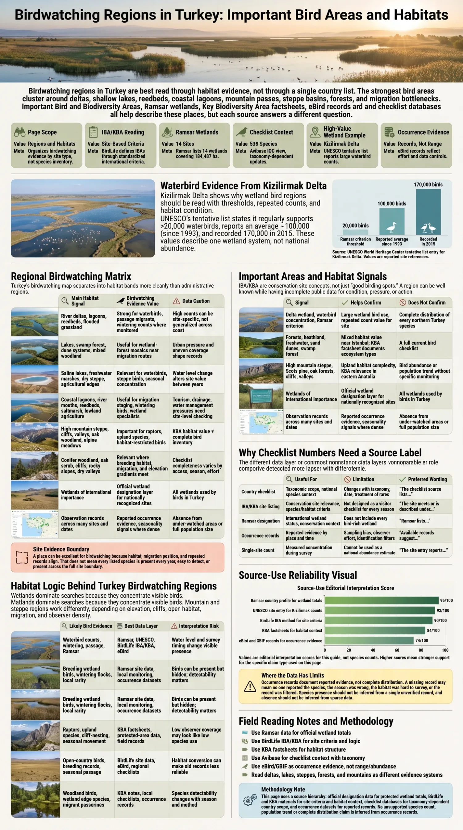
Turkey’s main birdwatching regions are the Bosphorus and Marmara migration corridor, the deltas and flooded forests of the Black Sea coast, Aegean and Mediterranean wetlands, the saline basins and steppe of Central Anatolia, the southwest Lakes District, the Eastern Black Sea–Caucasus mountains, the high plateaus of Eastern Anatolia and the Euphrates–Tigris river valleys. Each region supports a different bird community because migration routes, water chemistry, vegetation, elevation and seasonal water levels differ sharply across the country.
A narrow strait can concentrate thousands of soaring migrants, while a coastal delta may support breeding colonies, wintering waterbirds and passage shorebirds within the same landscape. Inland saline lakes favour a different assemblage from freshwater reedbeds, and alpine scree above the treeline holds birds absent from the coastal lowlands. A useful birdwatching map of Turkey therefore begins with habitats and seasonal movement rather than provincial boundaries.
IBA, KBA, Ramsar and eBird Hotspot Are Different Labels
An Important Bird and Biodiversity Area, or IBA, is identified through BirdLife’s standardized criteria and population thresholds. Qualification depends on evidence that a site supports birds meeting one or more global criteria; it is not simply a place with a long species list or frequent birdwatcher visits.[a]
| Label | Basis | Value for Birdwatching Research | Main Limitation |
|---|---|---|---|
| Important Bird and Biodiversity Area | Bird populations assessed against BirdLife criteria and numerical thresholds | Identifies places with international importance for threatened, restricted-range, biome-restricted or congregatory birds | The assessment year may be old, and qualification does not guarantee public access or current viewing conditions |
| Key Biodiversity Area | Global biodiversity criteria that can include birds, mammals, plants and other taxa | Provides site boundaries, trigger taxa, habitat descriptions, pressures and assessment history | A KBA may qualify for non-avian biodiversity, and older trigger records may require current field verification |
| Ramsar Site | Wetland designation under the Convention on Wetlands | Identifies internationally recognized wetland systems and their ecological character | Ramsar status is not a ranking of birdwatching quality, and its boundary may differ from an IBA or KBA boundary |
| eBird Hotspot | A shared observation location used for community checklists | Shows reported species, recent visits, seasonal records and observer activity | Records reflect observer effort, access and reporting choices; a hotspot is not a conservation designation |
eBird hotspots are shared birding locations contributed by users. Their regional pages can show recent checklists and recorded species, but a heavily visited city wetland may accumulate more records than a less accessible KBA with greater conservation importance.[e]
Turkey’s Headline Site Counts Belong to Different Inventories
Doğa Derneği’s account of the national IBA update states that Turkey had 184 IBAs in the inventory updated in 2004 and that later changes in bird knowledge and site pressures required a new review.[b] The national KBA publication reports 305 KBAs covering about 26% of the country, but it explicitly identifies those statistics as products of the 2006 inventory and warns that they may change after revision.[c] The Ramsar Convention’s current country table lists 14 Ramsar Sites for Türkiye.[d] These numbers cannot be added together or treated as a time series because their criteria, boundaries and dates differ.
Regional Birdwatching Geography
| Region | Representative Areas | Defining Habitats | Main Seasonal Signal |
|---|---|---|---|
| Istanbul and Marmara | Bosphorus, Lake Manyas and surrounding lowlands | Migration bottleneck, shallow freshwater lake, reed fringe, wet meadow, farmland and woodland edge | Spring and autumn soaring-bird passage; winter waterbirds |
| Black Sea Coast | Kızılırmak Delta and İğneada Forests | Lagoons, reedbeds, dunes, marsh, flooded forest, freshwater lakes and coastal woodland | Passage and wintering waterbirds; breeding wetland and forest birds |
| Aegean Coast | Gediz Delta, Büyük Menderes Delta and Bafa Lake | Saltpans, lagoons, mudflats, saltmarsh, reedbeds, wet meadows, agricultural land and Mediterranean scrub | Autumn and winter waterbirds; spring shorebird passage; colonial breeding birds |
| Mediterranean Coast and Amanos | Göksu Delta, Amanos Mountains and Belen Pass | Coastal lagoons, dunes, reedbeds, river mouths, lowland agriculture, forested slopes and mountain passes | Spring and autumn migration; wetland breeding and wintering |
| Central Anatolian Plateau | Tuz Lake, Sultan Marshes and Seyfe Lake | Saline lake, freshwater marsh, reedbed, wet meadow, alkaline steppe and seasonal mudflat | Spring passage and breeding; water-level-dependent autumn and winter use |
| Southwest Lakes District | Burdur Lake and neighbouring closed basins | Deep saline lake, shallow salt lake, exposed shore, steppe and agricultural mosaic | Wintering diving ducks and other waterbirds; passage along receding shorelines |
| Taurus Highlands | Bolkar Mountains and adjoining uplands | Conifer forest, juniper, rocky slope, cliff, alpine grassland, scree and glacier lake | Late spring and summer mountain birds; raptors throughout the ice-free period |
| Eastern Black Sea and Caucasus | Çoruh Valley, Soğanlı, Kaçkar and Karçal mountains | Colchic forest, conifer woodland, rhododendron scrub, alpine meadow, cliff, scree and river valley | Autumn raptor migration; late spring and summer forest and alpine birds |
| Eastern Anatolian Plateau | Kuyucuk Lake and the Kars–Aras landscape | High-elevation lake, wet meadow, open steppe, pasture, cereal field and riparian corridor | Spring and autumn passage; short highland breeding season |
| Southeastern River Valleys | Dicle Valley and the Birecik–Euphrates corridor | River channel, sandbank, island, cliff, dry scrub, semi-arid steppe and sparse oak woodland | Spring arrival and summer breeding; passage along river corridors |
The Bosphorus and Marmara Migration Corridor
The Bosphorus is a migration bottleneck rather than a self-contained habitat reserve. Soaring birds avoid long crossings over open water and become concentrated near the strait. The KBA factsheet identifies it as a regular passage corridor for more than 20,000 storks and raptors during spring and autumn migration.[h] White Storks, European Honey-buzzards, Common Buzzards, eagles, harriers and other migrants can pass in waves shaped by wind direction, cloud cover and thermal formation.
A low-count day does not mean that migration has ended. Birds may cross on a different line, remain grounded during poor weather or pass at heights that make detection difficult. Observation points on both sides of the strait also differ in morning light, wind exposure and the direction from which birds approach.
Southwest of the strait, Lake Manyas adds a contrasting freshwater system. Its KBA account describes a shallow, nutrient-rich lake with river deltas, marshes, reed belts and tree-lined banks. These habitats support breeding and wintering waterbirds, while migrating Great White Pelicans use the lake as a roost.[i] The Marmara region can therefore combine soaring-bird migration with lake, reedbed and agricultural birding within a relatively compact area.
Black Sea Deltas, Lagoons and Flooded Forests
The Kızılırmak Delta contains one of Turkey’s broadest coastal wetland mosaics. The KBA factsheet describes open water, freshwater and brackish lagoons, extensive reedbeds, seasonally flooded woodland, sand dunes, wet meadows and farmland. It identifies the delta as the largest intact wetland system on the Turkish Black Sea coast and records importance for breeding, passage and wintering waterbirds.[f]
Habitat transitions make the delta more productive than a single lake shoreline. Mudflats and shallow pools attract shorebirds; reedbeds hold rails, herons and reed-nesting passerines; flooded alder and ash woodland supports forest birds; open fields add larks, pipits, wagtails and raptors. The factsheet’s 2004 assessment reported more than 10,000 waders during spring passage, but that figure should be retained as dated survey evidence rather than presented as a current annual count.
Farther west, İğneada combines seasonally flooded forests, swamps, freshwater lakes and coastal dunes near the Bulgarian border. Its value comes from the close contact between forest, wetland and dune habitats rather than a single large waterbody.[g] Spring breeding activity and autumn passage can produce very different lists, while winter water levels determine how much flooded woodland and shallow feeding habitat remains available.
Aegean Deltas, Saltpans and Coastal Lagoons
The Gediz Delta beside İzmir is built from lagoons, reedbeds, fresh and saline marshes, salt meadows, wet and dry grassland, seasonally flooded fields, islets, farmland and Mediterranean scrub. BirdLife reports 303 bird species from the delta and around 15,000 breeding pairs of Greater Flamingo.[j] The cumulative species total represents recorded use of the wider delta through many seasons, not the number expected during one visit.
Water depth divides the bird community into visible bands. Flamingos and larger waders feed in shallow saline water; small sandpipers and plovers use exposed mud; terns and gulls concentrate around islets and channels; reedbeds hold secretive wetland birds; and dry margins support larks, wheatears and other open-country species. Working saltpans can provide feeding and roosting habitat, but access and disturbance rules may vary among compartments.
The Büyük Menderes Delta has a different balance of mudflats, lagoons, salt-steppe vegetation, sandbar and agricultural land. Its KBA account identifies breeding and wintering waterbirds as major elements of the site.[k] Nearby Bafa Lake is slightly saline and includes western-shore marshes used by breeding waders and wintering waterbirds; Dalmatian Pelicans also move into the lake from the Menderes system.[l] Treating the delta and lake as connected but distinct habitats produces a more accurate regional picture than merging them into one generic coastal wetland.
Göksu Delta and the Amanos Migration Passage
The Göksu Delta on the Mediterranean coast contains lagoons, marshes, reedbeds, dunes, beaches, river channels and cultivated land. Its KBA factsheet records 332 bird species and reports 90 thought to breed, while also identifying the area as a stopover for Great White Pelicans and White Storks and as a wintering area for waterbirds and raptors.[m] These figures are cumulative site records linked to the factsheet’s assessment history; they are not a current one-day inventory.
The Mediterranean lowlands become especially active during migration because coastal wetlands provide feeding and resting habitat before or after demanding crossings. Shorebirds may use exposed lagoon margins, passerines concentrate in scrub and reed edges, and raptors hunt over farmland and marsh. Breeding-season visits require greater distance from colonies, reedbed territories and beach-nesting birds.
East of the Çukurova lowlands, the Amanos Mountains form a north–south ridge between Mediterranean Turkey and the Syrian plateau. The Belen area is a migration bottleneck for storks, pelicans and raptors.[n] Large totals frequently quoted for Belen come from limited historical survey periods, including work in 1976 and 1992. They show the corridor’s migration function but should not be presented as a current annual mean without a newer standardized count.
Central Anatolian Saline Basins, Marshes and Steppe
Central Anatolia is defined by closed drainage basins, strong evaporation, seasonal water fluctuations and broad steppe landscapes. The resulting birding conditions differ from the wooded coasts. Water may retreat over large distances during summer, freshwater marsh may sit beside saline flats, and productive observation points can move as shorelines change.
Sultan Marshes combines freshwater and saline lakes, reedbeds, extensive marsh, wet meadow and salt-tolerant steppe vegetation. Its KBA account identifies the basin as an area for breeding, passage and wintering waterbirds while also recording water abstraction, drainage and agricultural change among the pressures affecting the wetland system.[o] A historic reputation for high bird numbers does not remove the need to check present water conditions.
Tuz Lake is an immense saline basin surrounded by salt steppe, cultivated land and seasonal wetlands. Its KBA assessment lists Greater Flamingo and Armenian Gull among bird trigger taxa and also records open-country species such as Common Crane and Great Bustard within the wider site assessment.[p] Flamingo breeding areas and other colony locations are sensitive, often remote and unsuitable for close approach.
Seyfe Lake adds a shallow brackish lake, islands, marsh and surrounding steppe to the Central Anatolian network. Its KBA account records use by breeding waterbirds and wintering wildfowl while describing water diversion and agricultural expansion as pressures on the basin.[q] Records from wet years, dry years and partly desiccated periods should not be combined without retaining their dates and water conditions.
The Southwest Lakes District
The southwest interior contains saline and alkaline lakes separated by dry uplands, farmland and steppe. Burdur Lake is a large, deep saline lake in a closed basin. Its KBA factsheet identifies it as an important wintering waterbird site and historically treats it as a major wintering area for White-headed Duck.[r] Because both lake level and duck distribution have changed over time, historical population statements should be attached to their source year rather than repeated as present conditions.
Nearby shallow basins may expose broad mudflats or almost dry during summer. These sites can hold passage shorebirds when suitable shallow water remains, but they can also appear nearly empty during prolonged drought or when birds move to another basin. Regional planning is more reliable when several lakes are considered together and recent water information is checked before travel.
Taurus Forests, Cliffs and Alpine Ground
The coastal Mediterranean wetlands rise sharply into the Taurus Mountains. In the Bolkar Mountains, conifer forest, juniper, cliff, scree, alpine grassland and high-elevation lakes replace the lagoon and marsh habitats of the lowlands. The KBA assessment lists mountain birds including Caspian Snowcock, Bearded Vulture, Griffon Vulture, Golden Eagle, Krüper’s Nuthatch and Wallcreeper.[s]
Elevation determines both access and timing. Forest birds may be active while higher routes remain snowbound, and alpine species may not become readily detectable until late spring or early summer. Wind, cloud and midday heat also alter raptor visibility along ridges and cliffs.
Eastern Black Sea Mountains and the Çoruh Corridor
The Eastern Black Sea Mountains extend from humid coastal forest to peaks above 3,000 metres. Their KBA factsheet covers the Çoruh Valley and the Soğanlı, Kaçkar and Karçal ranges, with Colchic forest, conifer woodland, rhododendron scrub, alpine grassland, cliffs, scree and glacial lakes. It also identifies the Çoruh and adjoining valleys as a major raptor migration bottleneck.[t]
This is one of the clearest examples of elevation zonation shaping a regional bird list. Lower deciduous forest supports one assemblage, conifer and mixed woodland another, and alpine areas hold Caucasian Grouse, Caspian Snowcock, choughs, accentors and other high-mountain birds. Some species occupy narrow elevation and habitat bands, so a single valley-bottom checklist cannot represent the mountain system.
Autumn migration adds a separate layer. Raptors following the eastern Black Sea and Caucasus corridor can concentrate through valleys and passes, while the resident and breeding mountain community remains distributed across forest and alpine zones. Weather that closes high elevations can still allow productive observation lower in the Çoruh Valley.
Eastern Anatolian Plateau Wetlands
Eastern Anatolia contains broad plateaus, shallow lakes, wet meadows, pasture, cereal fields and river corridors at elevations where winter is long and the breeding season is compressed. Kuyucuk Lake lies on the Kars–Akyaka plateau in an open landscape of grazing land and cereal cultivation. Its KBA account identifies the lake as breeding habitat for waterbirds and describes sparse emergent vegetation around the freshwater basin.[u]
Spring passage can be conspicuous as ice retreats and shallow feeding areas reopen. Summer adds breeding ducks, grebes, waders and open-country birds, while autumn gathers migrants before freezing conditions return. Because the productive window is short, dates that work on the Aegean coast may be too early for plateau breeders or too late for peak passage in the east.
Dicle and Euphrates River Landscapes
Southeastern Turkey replaces high plateau wetlands with warmer river valleys, canyons, sandbanks, islands, dry plains, sparse oak woodland and semi-arid steppe. The Dicle Valley KBA account describes a river-and-canyon mosaic shaped by seasonal flooding and records birds including Bonelli’s Eagle, Egyptian Vulture, Griffon Vulture, Lesser Kestrel, Little Swift, Cinereous Bunting and Pied Kingfisher.[v]
Different parts of the valley serve different guilds. Cliffs provide nesting and roosting structures for raptors and swifts; riverbanks and islands support kingfishers and other waterside birds; dry slopes and steppe hold buntings, larks and wheatears. Reservoir creation, river engineering, quarrying and changing agricultural use can alter these habitats without removing the valley’s broad geographic identity.
Birecik on the Euphrates is closely associated with the Northern Bald Ibis. BirdLife’s species account treats the managed Birecik population as semi-wild, so it should not be described as a fully unmanaged wild colony.[w] The distinction matters when comparing sightings, breeding records and population figures with wild populations elsewhere in the species’ range.
Habitat Structure Predicts the Bird Assemblage
Place names alone do not explain which birds are likely to occur. Water depth, salinity, vegetation height, substrate, elevation and topography provide a more reliable first filter. The same region may contain several habitat systems with little overlap in their most characteristic birds.
| Habitat System | Regional Examples | Bird Groups Commonly Associated with the Habitat | Field Variables |
|---|---|---|---|
| Soaring-bird bottleneck | Bosphorus, Belen Pass and Çoruh Valley | Storks, pelicans, European Honey-buzzards, buzzards, eagles, harriers and falcons | Wind direction, thermal strength, cloud base, visibility and observation position |
| Coastal lagoon, saltpan and mudflat | Gediz, Büyük Menderes and Göksu deltas | Flamingos, pelicans, avocets, stilts, plovers, sandpipers, gulls and terns | Water depth, exposed mud, salinity, tidal or managed water movement and disturbance |
| Freshwater reedbed and marsh | Kızılırmak Delta, Lake Manyas and Sultan Marshes | Herons, bitterns, rails, crakes, grebes, ducks and reed-nesting passerines | Reed density, open-water channels, seasonal flooding, water quality and edge access |
| Flooded coastal forest | İğneada and woodland sectors of the Kızılırmak Delta | Woodpeckers, flycatchers, tits, warblers, thrushes and woodland raptors | Flood depth, canopy structure, deadwood, forest edge and breeding-season disturbance |
| Saline inland lake and alkaline steppe | Tuz Lake, Seyfe and southwest closed basins | Flamingos, shelducks, avocets, gulls, cranes, larks, wheatears and bustards | Annual rainfall, shoreline retreat, salt crust, shallow pools and surrounding land use |
| Montane forest | Taurus and Eastern Black Sea ranges | Krüper’s Nuthatch, woodpeckers, flycatchers, forest warblers and woodland raptors | Tree composition, elevation, snow cover, slope aspect and forest continuity |
| Alpine grassland, cliff and scree | Bolkar, Kaçkar and Karçal mountains | Snowcocks, Caucasian Grouse, Wallcreeper, accentors, choughs, vultures and eagles | Snowmelt, altitude, grazing intensity, wind and safe route access |
| High plateau lake and wet meadow | Kuyucuk and the Kars plateau | Breeding ducks, grebes, waders, cranes, larks, pipits and harriers | Ice break-up, meadow flooding, grazing, lake depth and the short breeding season |
| River canyon, cliff and sandbank | Dicle and Euphrates valleys | Kingfishers, swifts, bee-eaters, sandbank nesters, buntings, vultures and eagles | River flow, bank erosion, reservoir levels, cliff disturbance and summer heat |
Season Changes Which Region Is Most Productive
Spring Passage
Spring movement begins earliest in southern and western lowlands and reaches high eastern plateaus and alpine systems later. From late February into May, coastal wetlands receive shorebirds, waterbirds and passerines moving north. The Bosphorus and Belen corridor can concentrate soaring migrants, while Black Sea and Aegean deltas provide feeding areas during stopovers.
Timing is weather-dependent. Headwinds may hold birds at wetlands, favourable winds may produce rapid departures, and cold conditions can delay arrival at high elevations. A regional plan that combines a migration watchpoint with nearby wetland or woodland habitat is less dependent on one weather pattern.
Breeding Period
From April into July, lowland reedbeds, dunes, steppe and farmland hold territorial and nesting birds. Alpine breeding activity starts later as snow retreats. This period is useful for detecting songs, display flights and localized breeding species, but it is also the season when careless approach, playback and repeated photography can cause the greatest disturbance.
Colonial waterbirds, ground-nesting shorebirds, bustards, grouse and birds using exposed cliffs or sandbanks require extra distance. A bird remaining motionless, giving alarm calls, carrying food or repeatedly leaving and returning to one point may indicate that the observer is too close to a nest or dependent young.
Autumn Passage
Autumn migration extends from late summer into November, with timing differing among shorebirds, passerines and soaring birds. Mudflats exposed by falling water can attract passage waders before wintering ducks arrive. The Bosphorus, Belen and Çoruh corridors become prominent for raptors and storks, while deltas and river valleys act as feeding and resting systems.
Juvenile birds increase identification difficulty during this period. Worn plumage, partial moult and variable light can make field photographs and sound recordings more useful than unsupported certainty, especially for rare or out-of-range reports.
Winter
Winter shifts attention toward unfrozen coastal wetlands, the Marmara region, the Aegean and Mediterranean deltas and suitable inland lakes. Waterbird distribution can change quickly with freezing, storms, water levels and food supply. High eastern plateaus may become inaccessible or largely frozen, while lower river valleys and seacoasts remain active.
Winter counts are not automatically comparable among years. A large concentration may reflect displacement from frozen wetlands elsewhere, and a low count may result from birds using an unobserved sector of the same basin. Survey coverage, dates and weather belong with the count.
Why Site Lists and Observation Totals Disagree
An IBA or KBA factsheet may preserve the trigger species and count data used in an older assessment. An eBird regional list may include later observations, escaped birds, rare visitors and records under newer taxonomy. A Ramsar information sheet may describe a different boundary, while a national checklist may apply its own rules for uncertain, introduced or historical records.
Taxonomic revisions also change totals and names. AviList now provides a unified global bird checklist developed through international taxonomic collaboration, but older KBA factsheets and regional publications may retain earlier genus assignments, species limits or English names.[x] A scientific name copied from an old site account should therefore be checked against a current taxonomic authority before publication.
Observation databases carry spatial bias. Roadside wetlands, city parks and sites with viewing infrastructure receive more complete coverage than military zones, privately managed saltpans, remote mountains or marshes without safe access. An empty map cell may represent low observer effort rather than true absence, while one isolated report is not enough to establish regular regional occurrence.
A Site Total Is a Cumulative Record, Not a One-Day List
Published site totals usually combine breeding records, winter visitors, passage migrants, irregular visitors and historical observations accumulated across many years. The total may also change after taxonomic splits or record review. A field visit should be assessed against season, habitat coverage, water conditions, weather and observer effort rather than the headline total alone.
Birdwatching Without Adding Pressure
Many of Turkey’s sought-after birds use colonies, display grounds, nests, roosts or narrow migration watchpoints where repeated disturbance can accumulate. eBird withholds or obscures locations for selected sensitive species when public coordinates could increase capture, hunting, nest disturbance or crowding risks.[y]
- Remain on public roads, marked paths and authorized observation areas unless the land manager permits other access.
- Increase distance when a bird changes posture, gives alarm calls, interrupts feeding, leaves a nest area or repeatedly watches the observer.
- Avoid approaching colonies, cliff nests, ground nests, display grounds and communal roosts for closer photographs.
- Use playback sparingly or not at all around localized breeders, owls, grouse, nesting raptors and birds already being watched by several people.
- Do not publish precise coordinates for sensitive nests, colonies or rare breeding birds.
- Keep vehicles from blocking farm access, village roads, emergency routes and established migration watchpoints.
- Record date, duration, distance travelled, observer number and habitat coverage when submitting checklists so that the record retains useful effort information.
- Report uncertain identifications as uncertain and retain photographs, sound recordings or field notes for records requiring review.
The American Birding Association’s ethics code similarly places bird welfare before observation, photography or sound recording and calls for particular caution around nests, colonies, roosts and display areas.[z]
Sources and Verification
- [a] BirdLife International — Important Bird and Biodiversity Areas — Used for the definition of an IBA and the role of standardized population criteria.
- [b] Doğa Derneği — Important Bird Areas Update — Used for the 184-site figure, its connection to the 2004 inventory and the stated need for revision.
- [c] Doğa Derneği — Key Biodiversity Areas of Turkey — Used for the 305-site and land-coverage statistics and the publication’s warning that they derive from the 2006 inventory.
- [d] Convention on Wetlands — Contracting Parties — Used for the current number of Ramsar Sites listed for Türkiye.
- [e] eBird — Explore Regions and Hotspots — Used to distinguish shared observation hotspots from formal conservation designations.
- [f] KBA Partnership — Kızılırmak Delta — Used for the delta’s habitat mosaic, Black Sea coastal context and dated migration evidence.
- [g] BirdLife DataZone — İğneada Forests — Used for the flooded forest, swamp, freshwater lake and dune habitat complex.
- [h] KBA Partnership — Bosphorus — Used for the strait’s migration-bottleneck function and regular passage of storks and raptors.
- [i] KBA Partnership — Manyas Lake — Used for the shallow lake habitats and breeding, wintering and pelican use.
- [j] BirdLife International — Gediz Delta — Used for the reported species total, Greater Flamingo breeding estimate and detailed coastal habitat mosaic.
- [k] KBA Partnership — Büyük Menderes Delta — Used for the delta’s lagoon, mudflat, sandbar and salt-steppe habitats.
- [l] KBA Partnership — Bafa Lake — Used for lake salinity, western marshes, breeding waders and pelican movement from the Menderes system.
- [m] KBA Partnership — Göksu Delta — Used for cumulative bird records, breeding evidence, migration use and wetland habitats.
- [n] KBA Partnership — Amanos Mountains — Used for the Belen migration bottleneck and the dates attached to historical migration surveys.
- [o] KBA Partnership — Sultan Marshes — Used for the freshwater, saline, marsh and steppe mosaic and recorded hydrological pressures.
- [p] KBA Partnership — Tuz Lake Assessment — Used for selected bird trigger taxa associated with the lake and surrounding open country.
- [q] KBA Partnership — Seyfe Lake — Used for the brackish lake, island, marsh and steppe habitats and documented water-related pressures.
- [r] KBA Partnership — Burdur Lake — Used for the closed-basin saline lake setting and its historical importance for wintering White-headed Duck.
- [s] KBA Partnership — Bolkar Mountains Assessment — Used for selected forest, cliff and alpine bird taxa recorded in the mountain assessment.
- [t] KBA Partnership — Eastern Black Sea Mountains — Used for the mountain ranges, habitat zonation, alpine birds and Çoruh migration corridor.
- [u] KBA Partnership — Kuyucuk Lake — Used for the high plateau lake setting, surrounding land use and breeding-waterbird role.
- [v] KBA Partnership — Dicle Valley — Used for the river-canyon habitat mosaic and representative southeastern bird taxa.
- [w] BirdLife DataZone — Northern Bald Ibis — Used to verify the semi-wild classification of the managed Birecik population.
- [x] AviList — Global Avian Checklist — Used for the current unified taxonomic reference and the explanation of name differences among older sources.
- [y] eBird — Sensitive Species — Used for location-obscuring practices intended to reduce capture, hunting and disturbance risks.
- [z] American Birding Association — Code of Birding Ethics — Used for low-disturbance conduct around nests, colonies, roosts and display areas.
Related Topics
- → Migratory Birds in Turkey: Major Flyways and Seasonal Patterns
- → Birds of Turkish Wetlands: Lakes, Deltas, and Marshes
- → Steppe Birds of Turkey: Open-Country Species
- → Forest Birds of Turkey: Woodland Species and Habitats
- → Common Birds of Turkey: Species Often Seen Across the Country
- → Raptors of Turkey: Eagles, Hawks, Falcons, and Vultures