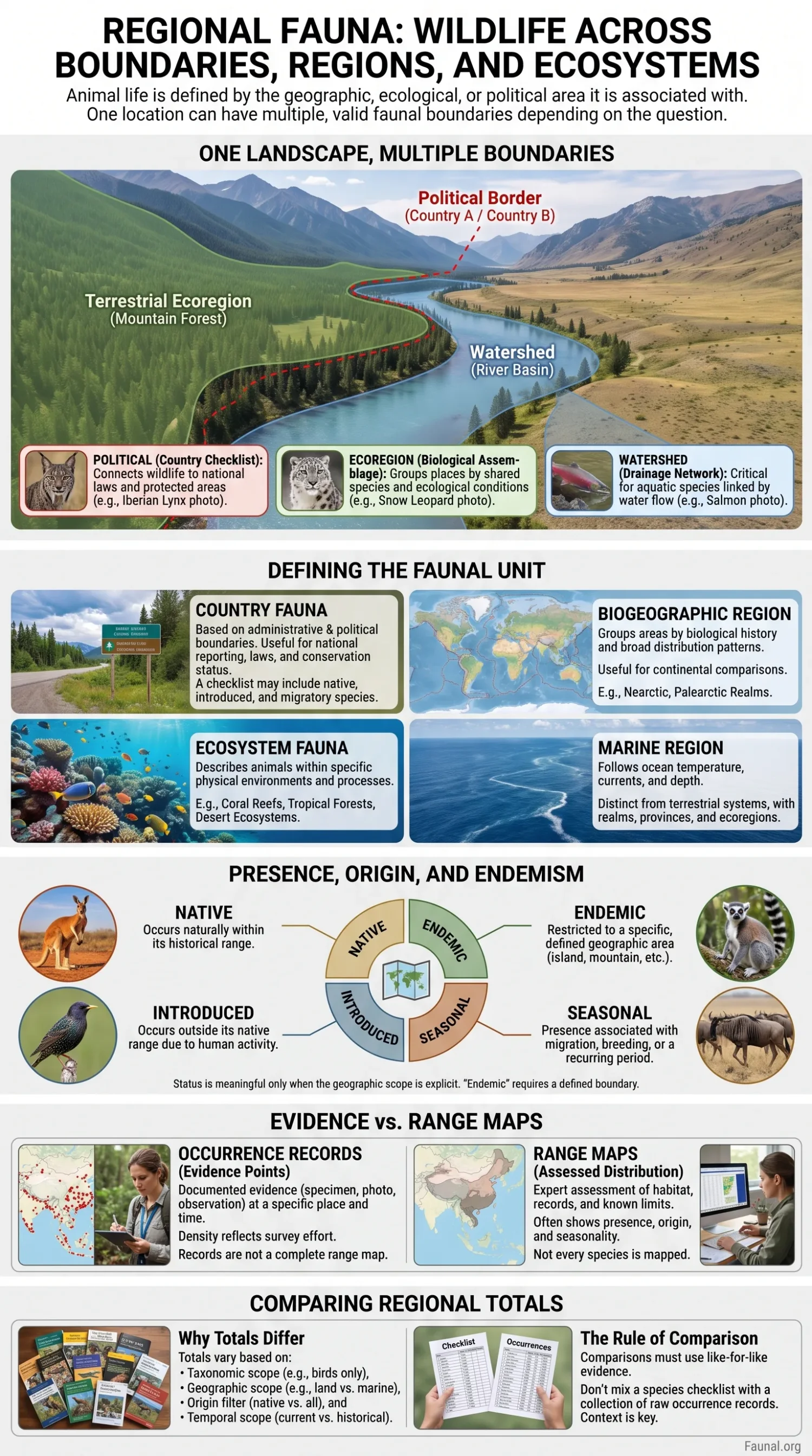
Regional fauna is the animal life associated with a defined geographic or ecological area. That area may be a country, island, mountain system, river basin, terrestrial ecoregion, marine region or ecosystem type. The animals included in a regional fauna therefore depend on where the boundary is drawn, which taxa are covered, which period is considered and what kind of evidence is accepted. A national checklist, an ecoregion species inventory and an ecosystem-based fauna account can all describe the same part of Earth while answering different biological questions.
One Landscape Can Have Several Valid Faunal Boundaries
Animals do not normally follow political borders. Mountain chains continue across states, river systems cross countries, migratory routes connect continents and marine populations move through waters governed by several jurisdictions. Political boundaries remain useful because national agencies, laws, protected-area systems and biodiversity inventories are usually organized around them. Ecological boundaries answer a different question: where environmental conditions and biological assemblages change.
| Regional unit | What defines it | Best suited to | Main limitation |
|---|---|---|---|
| Country or territory | Administrative and political boundary | National checklists, wildlife law, protected status, reporting and country occurrence | The border may divide one continuous habitat or animal population |
| Biogeographic realm | Large-scale history and broad patterns of biological distribution | Continental-scale comparisons and evolutionary geography | Too broad for many local habitat and species questions |
| Ecoregion | Regional environmental conditions and characteristic biological assemblages | Comparing fauna across ecologically distinct landscapes | Fine local habitats may remain hidden within the larger unit |
| Ecosystem | Ecological processes, physical environment and biological composition | Linking animals to forests, grasslands, wetlands, reefs and other ecological systems | Mobile species may use several ecosystem types during their life cycle |
| Watershed or drainage basin | Connected surface-water drainage | Freshwater fishes, amphibians, aquatic invertebrates and river-associated wildlife | It is less suitable for terrestrial species whose ranges do not track drainage boundaries |
| Marine ecoregion | Coastal and shelf biogeography | Marine assemblages, coastal conservation and regional ocean comparisons | Highly mobile oceanic species may extend far beyond one unit |
| Island or archipelago | Geographic isolation by surrounding water | Endemism, colonization, extinction history and introduced species | Marine visitors and migratory animals may connect the island with much wider regions |
| Protected area | Legally or administratively designated management boundary | Local inventories, monitoring and conservation management | The protected boundary rarely contains the complete ranges of its animals |
A regional species list is meaningful only when its geographic scope is explicit. “Fauna of Brazil,” “fauna of the Amazon basin” and “fauna of Amazonian moist forest ecoregions” are related subjects, but they do not describe identical sets of animals.
Country Fauna Connects Wildlife with Administrative Geography
Country boundaries are among the most practical units for organizing wildlife information. National governments publish species inventories, threatened-species lists, hunting and wildlife regulations, protected-species schedules and biodiversity reports within those borders. Global taxonomic and conservation datasets also commonly encode countries of occurrence.
A country fauna should not be treated as one undifferentiated list. A species may be native, introduced, reintroduced, migratory, vagrant, historically recorded or of uncertain presence. The IUCN Red List geographic-range system separates country records by presence, origin and seasonality, allowing an assessment to distinguish native residents from introduced populations, vagrants and seasonal occurrences. IUCN Red List geographic-range documentation
This distinction matters especially for birds, marine animals and other mobile species. An animal recorded within a country’s borders during migration is part of its documented fauna under an appropriately defined checklist, but that record does not make the country the species’ year-round range or breeding area.
Biogeographic Regions Follow Biological Turnover Across Borders
Biogeographic regionalization groups places according to patterns in species composition, ecological conditions and biological history rather than government boundaries. It is particularly useful when similar animal communities extend across several countries or when one large country contains sharply different faunas.
A widely used terrestrial regionalization revised by Dinerstein and colleagues recognizes 846 terrestrial ecoregions within 14 terrestrial biomes. These ecoregions provide spatial units for comparing biodiversity across landscapes that may cross national borders. Dinerstein et al., 2017
An ecoregion is not a species checklist by itself. A mapped ecoregion identifies an ecological and geographic unit; the animals attributed to it still require taxonomic records, occurrence evidence, range information or field inventories. Border cells are also not biological walls. Species distributions can extend into neighboring ecoregions, and transitional areas often contain animals associated with more than one ecological system.
Marine Regions Use a Different Geography
Terrestrial ecoregions cannot simply be extended into the sea. Ocean temperature, currents, depth, substrate, coastlines and barriers to marine dispersal create different spatial patterns. The Marine Ecoregions of the World system developed for coastal and shelf waters contains 12 realms, 62 provinces and 232 ecoregions. Spalding et al., 2007
That hierarchy illustrates why “regional wildlife” cannot rely on one universal map. A terrestrial mammal comparison, a reef-fish inventory and a river-basin amphibian study may require three different boundary systems even when all three concern places within the same country.
Ecosystem Fauna Describes the Environmental Setting Animals Use
Regional geography answers where a fauna is being described. Ecosystem classification adds information about the ecological setting in which animals occur. Forest canopies, desert surfaces, peatlands, rivers, caves, rocky shores, coral reefs and deep-sea environments impose very different physical conditions and provide different foods, shelters and breeding sites.
The IUCN Global Ecosystem Typology organizes ecosystems through a hierarchy that includes realms, biomes and ecosystem functional groups. Its upper levels emphasize ecological functions and drivers, while finer levels distinguish systems with different biological composition. IUCN Global Ecosystem Typology
An ecosystem association is not equivalent to a complete geographic range. A jaguar using tropical forest does not occur in every tropical forest. A shorebird associated with tidal flats may use only selected coastal sites during migration. Habitat suitability, dispersal barriers, historical colonization, prey availability, competition and human land use all influence which animals occupy otherwise similar ecosystems.
Freshwater Fauna Often Follows Drainage Networks
Freshwater animals present another boundary problem. River fishes, aquatic mollusks and many amphibians are linked to drainage connectivity rather than to the straight borders visible on political maps. Two neighboring valleys in the same country may drain toward different seas and support different freshwater assemblages. Conversely, one river basin may extend through several countries while remaining connected for aquatic organisms.
For these taxa, watershed or hydrographic boundaries can provide more biological information than national borders. Political geography remains relevant for regulation and conservation responsibility, but the drainage network often provides the stronger biological context.
Presence, Origin and Endemism Describe Different Parts of Regional Fauna
A species name alone does not explain its relationship with a region. Regional fauna data become more informative when occurrence is separated from origin, establishment, seasonality and geographic restriction.
| Regional status | What it communicates | What should not be assumed |
|---|---|---|
| Native | The species occurs within its natural range in the stated region | Native status does not imply that it occupies every habitat within that region |
| Endemic | The taxon’s natural geographic distribution is restricted to the stated area | Endemism must use a clearly defined geographic and taxonomic scope |
| Introduced | The species occurs outside its native range through human-mediated movement | An introduced species is not automatically invasive |
| Invasive | An introduced taxon is treated as invasive under the cited ecological or institutional assessment | The label should not be assigned merely because the species is non-native |
| Reintroduced | The species has been returned through conservation action to an area within its former range | The present population should not be confused with uninterrupted historical persistence |
| Vagrant | The species appears outside its usual distribution without forming a normal regional occurrence pattern | A vagrant record is not evidence of an established population |
| Seasonal | Presence is associated with breeding, non-breeding, migration or another recurring period | Seasonal occurrence does not establish year-round residency |
| Recorded occurrence | A source documents the taxon at a stated place and usually a stated time | An occurrence record alone does not establish the species’ complete regional distribution |
The geographic meaning of endemic also changes with the unit being discussed. A species may be endemic to an island, country, mountain range, lake, river system or ecoregion. The boundary must accompany the term. Without it, “endemic fauna” can hide very different range sizes.
Occurrence Records Are Evidence of Presence, Not a Finished Range Map
GBIF defines occurrence data as evidence that a species or other taxon occurred at a particular place at a specified time. Records can come from museum specimens, fossils, field surveys, citizen observations, camera traps and other data streams. Some records provide precise coordinates; others identify only a broader locality. GBIF dataset classes
A dense cluster of records can reflect genuine biological concentration, heavy survey effort or both. An apparent blank area can represent unsuitable habitat, true absence, inaccessible terrain, missing datasets or little observer activity. Regional occurrence maps therefore document available record-based evidence; they should not automatically be described as complete distributions.
Records and Ranges Are Different Evidence
A specimen or observation confirms a documented occurrence under the information supplied with that record. A species range normally requires broader evaluation of repeated records, habitat, survey coverage, known limits and expert assessment. The two forms of evidence can support each other, but they are not interchangeable.
IUCN spatial products take a different approach. Distribution maps associated with Red List assessments follow mapping standards and can encode presence, origin and seasonality. The Red List reported spatial data for more than 155,800 assessed species when its downloadable spatial-data page was updated in July 2026, while also noting that not every assessed species is mapped. IUCN Red List spatial data
Taxonomy Can Change a Regional Species List
Regional species totals depend on taxonomy as well as geography. A taxonomic revision may divide one recognized species into several, merge previously separate taxa, change a genus assignment or alter synonymy. Two regional lists built from different taxonomic editions can therefore report different totals without either list necessarily describing a biological change on the ground.
Catalogue of Life provides a versioned global species catalogue assembled from specialist taxonomic communities. Its release history allows a regional list to name the taxonomic reference used rather than treating scientific names as permanently fixed. The Catalogue itself also warns that global taxonomy remains incomplete and subject to correction. Catalogue of Life
For many animal groups, specialist databases provide a more focused taxonomic reference. Mammals, reptiles, amphibians, fishes and marine invertebrates do not have identical nomenclatural histories, geographic fields or update cycles. Regional fauna work is therefore stronger when the taxonomic register is chosen for the animal group rather than forcing every group through one source.
Different Animal Groups Require Different Data Sources
| Resource | Main regional-fauna use | Important scope boundary |
|---|---|---|
| Catalogue of Life | Accepted names, classification and synonym reconciliation across Animalia | A taxonomic catalogue does not by itself prove local occurrence |
| GBIF | Georeferenced and locality-based occurrence evidence from many data publishers | Record density is affected by sampling and publishing effort |
| IUCN Red List | Assessed geographic range, origin, seasonality, extinction-risk category and assessment context | Coverage and mapping availability differ among taxonomic groups |
| Mammal Diversity Database | Mammal taxonomy with country, continent and biogeographic information | Restricted to mammals |
| BirdLife DataZone | Bird distribution data and range mapping tied to BirdLife taxonomy | Distribution products follow their own taxonomy, metadata and access conditions |
| Amphibian Species of the World | Current amphibian taxonomy, nomenclature and geographic information | Its main emphasis is taxonomic and nomenclatural rather than detailed conservation assessment |
| Reptile Database | Reptile taxonomy, references and searchable geographic distribution fields | Country search results still require attention to the distribution notes for individual taxa |
| FishBase | Fish taxonomy, biology, country reports and ecosystem records | It covers finfishes rather than all aquatic animals |
| WoRMS | Accepted marine names, synonymy and marine taxonomic classification | Taxonomic presence in WoRMS should not be treated as proof of occurrence in a particular sea or coast |
The Mammal Diversity Database is maintained by the American Society of Mammalogists and is updated as mammal taxonomy changes. Version 2.5, released in July 2026, includes country, continent and biogeographic-realm information alongside its mammal taxonomy. Mammal Diversity Database
For birds, BirdLife DataZone provides global distribution maps for more than 11,000 species under the BirdLife taxonomic checklist, with updates connected to Red List releases. BirdLife DataZone
Amphibian Species of the World is curated by the American Museum of Natural History as a taxonomic and nomenclatural database containing current amphibian taxonomy, distribution and primary literature. Amphibian Species of the World
The Reptile Database supports searches by taxon and distribution and links reptile records to taxonomic references. Reptile Database
FishBase combines taxonomy with biological and geographic information for finfishes. Its February 2026 statistics reported more than 36,500 species and included both country reports and ecosystem reports, making it useful when fish fauna must be examined at more than one geographic scale. FishBase
For marine names, the World Register of Marine Species maintains an expert-edited catalogue intended to reflect published knowledge of marine taxonomy without making new taxonomic decisions itself. World Register of Marine Species
Why Regional Wildlife Totals Differ Between Sources
A statement such as “this country has 600 animal species” is incomplete unless the source explains what was counted. Species totals can differ because one list includes only native species while another includes introduced animals; one includes marine waters while another stops at the coastline; one includes vagrants while another requires established populations; or the lists follow different taxonomic editions.
- Taxonomic scope: vertebrates only, all animals, one class, one order or another defined taxon set.
- Geographic scope: land territory, territorial waters, offshore islands, overseas territories, a drainage basin or another boundary.
- Origin filter: native, introduced, reintroduced or all recorded origins.
- Seasonality: resident, breeding, non-breeding, passage migrant or vagrant.
- Temporal scope: current fauna, historical records, fossils or records from a stated survey period.
- Taxonomic edition: accepted names and species limits under a named database or checklist version.
- Evidence threshold: official checklist entry, reviewed range assessment, specimen, observation or another record type.
A larger number is therefore not automatically a better estimate. The useful figure is the one whose boundary, taxonomy and inclusion rules match the biological question being asked.
Regional Conservation Status Must Keep Its Geographic Scale
Species distribution and extinction risk are related but separate data. A species can occur in many countries while facing a high global extinction risk, or it can be globally widespread while receiving a different conservation assessment within one country or province. A regional wildlife page should therefore name whether a status is global, national or subnational and identify the assessment behind it.
The same separation applies to ecosystems. A species-level Red List category does not describe the condition of every ecosystem used by that species, and ecosystem risk does not assign an extinction category to each animal within it. Species assessments and ecosystem assessments answer different questions and should remain distinct.
Comparing Fauna Across Regions Requires Like-for-Like Evidence
Regional comparisons are most informative when both sides use the same taxonomic group, geographic rule, date range and evidence type. Comparing the number of mammals in one country’s reviewed checklist with every GBIF animal occurrence from another country would mix two different measurements. The first is a species inventory; the second is a collection of published records.
The same rule applies to ecosystems. A forest fauna should be compared with another forest fauna only after habitat definitions and taxonomic coverage are compatible. An ecoregion total should not be placed beside a national total without explaining that the areas were created for different purposes.
Regional fauna is best treated as a relationship between animals, geography and evidence. Countries provide administrative scope, biogeographic regions reveal biological turnover, ecosystems describe environmental associations, taxonomy determines which names are counted, and occurrence or assessment data determine what can be said about presence and range.
Sources and Verification
- Catalogue of Life — What Is COL — Versioned global taxonomic catalogue used for accepted-name and synonym context.
- Global Biodiversity Information Facility — Dataset Classes — Used for the distinction between checklist data and occurrence evidence tied to place and time.
- IUCN Red List of Threatened Species — Supporting Information: Geographic Range — Used for presence, origin and seasonality categories in species assessments.
- IUCN Red List of Threatened Species — Spatial Data Download — Used for the scope and July 2026 coverage of downloadable species spatial data.
- IUCN — Global Ecosystem Typology — Used for ecosystem classification by realms, biomes and finer ecosystem units.
- Dinerstein, E. et al. — An Ecoregion-Based Approach to Protecting Half the Terrestrial Realm, BioScience, 2017 — Used for the 846 terrestrial ecoregions and 14 terrestrial biomes in the cited regionalization.
- Spalding, M. D. et al. — Marine Ecoregions of the World: A Bioregionalization of Coastal and Shelf Areas, BioScience, 2007 — Used for the marine hierarchy of 12 realms, 62 provinces and 232 ecoregions.
- American Society of Mammalogists — Mammal Diversity Database — Used for mammal taxonomy, database versioning and regional geographic fields available in the 2026 database.
- BirdLife International — DataZone Dataset Information — Used for the scope of global bird distribution mapping and its taxonomic basis.
- American Museum of Natural History — Amphibian Species of the World 6.2 — Used for amphibian taxonomy, nomenclature, distribution and literature scope.
- The Reptile Database — Advanced Search — Used for reptile taxonomic and geographic distribution querying.
- FishBase — A Global Information System on Fishes — Used for February 2026 fish diversity statistics and the availability of country and ecosystem records.
- World Register of Marine Species — Used for expert-maintained marine taxonomic names and classification.
Fauna of Europe
Explore European fauna through regional species checklists, habitat zones, distribution records, and conservation status data.
Fauna of North Africa
Discover North African fauna with desert, mountain, wetland, and coastal species records, habitat data, and conservation context.
Fauna of the Amazon Rainforest
Explore Amazon rainforest fauna with species diversity data, habitat layers, occurrence records, and endangered animal summaries.
Fauna of the Mediterranean Basin
Explore Mediterranean wildlife with regional fauna checklists, coastal and scrubland habitats, species records, and conservation notes.
Fauna of the Middle East
Explore Middle Eastern fauna using regional species checklists, arid habitat data, occurrence records, and conservation summaries.
Fauna of Turkey
Explore the fauna of Turkey with native species checklists, habitat regions, occurrence records, and conservation status summaries.
6 sub-topics in Regional Fauna Guides