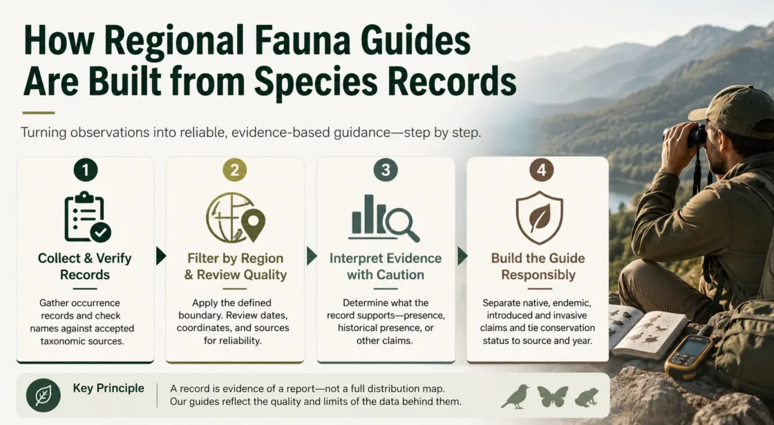
Complete guide: Regional Fauna Guides
Regional fauna guides are built by converting individual species records into a reviewed, taxonomically normalized, geographically bounded, and versioned account of animal occurrence. The raw inputs may include museum specimens, field observations, acoustic or camera detections, survey records, and earlier checklists. None enters the final guide solely because a name and coordinate appear in a database: each record must be tested against the guide’s place, period, taxonomic scope, evidence rules, and status definitions.
An occurrence record answers what taxon was reported, where, when, and on what evidence. A regional fauna guide must answer a different question: which taxa can be responsibly included for this region, under which names, and with what degree of support?
The Boundary Comes Before the Species List
Record retrieval should begin only after the region has been defined as a reproducible geometry. A country, province, island, watershed, protected area, mountain belt, coastal zone, or ecoregion can produce a different fauna even when the place name sounds similar. The scope must state whether inland waters, offshore islands, territorial seas, estuaries, caves, artificial habitats, and border zones are included.
Time and taxonomy also form part of the boundary. A guide may cover all documented records, only extant fauna, records after a stated year, breeding fauna, resident vertebrates, terrestrial invertebrates, or another defined set. Fossils, subfossils, zoo holdings, escaped animals, unidentified records, and records resolved only to genus should not be allowed to enter by accident.
| Scope decision | What must be fixed | Effect on the candidate records |
|---|---|---|
| Geographic geometry | A named polygon, boundary version, coordinate system, and treatment of islands or waters | Determines which localities are screened for possible inclusion |
| Time period | All dates, a historical interval, or a current-record threshold | Separates old evidence from records used to describe present occurrence |
| Taxonomic reach | Animal groups, ranks, and treatment of subspecies or unnamed taxa | Prevents higher-rank identifications from being counted as species |
| Wild-status rule | Whether captive, cultivated, escaped, released, or reintroduced animals are covered | Keeps ex-situ and non-wild records from being merged with wild fauna |
| Evidence threshold | Accepted record types and the review needed for difficult identifications | Controls which records become accepted, provisional, historical, or excluded entries |
An Occurrence Record Is a Dated Piece of Evidence
GBIF defines an occurrence dataset as evidence that a species or another taxon occurred at a particular place on a specified date. Its publication requirements place the record identifier, record type, scientific name, and event date at the center of the record, with country, coordinates, datum, coordinate uncertainty, and quantity fields adding geographic and biological context.[a]
Darwin Core supplies the shared vocabulary that allows records from museums, monitoring schemes, field surveys, research projects, and observation platforms to be combined. The field names do not certify that the values are correct; they make the meaning of each value explicit enough to test.[b]
| Record element | Contribution to a fauna guide | What it cannot establish alone |
|---|---|---|
occurrenceID |
Supports record-level tracing, deduplication, correction, and citation | That the identification or locality is valid |
scientificName and taxonRank |
Provides the reported identification and its taxonomic level | That the name is accepted, current, or resolved to species |
basisOfRecord |
Distinguishes observations, preserved specimens, fossils, living specimens, and other evidence forms | That every record type is suitable for a wild, present-day checklist |
eventDate |
Places the evidence in a date or date interval | That the species remains present in the region |
decimalLatitude, decimalLongitude, and coordinateUncertaintyInMeters |
Supports spatial screening while retaining uncertainty around the locality | That the true locality lies inside a narrow boundary |
occurrenceStatus |
Separates reported detection from reported non-detection where the field is supplied | That an unrecorded species was absent from an unsurveyed place |
identifiedBy, dateIdentified, and identification fields |
Expose who made the determination and whether later identification work exists | That a difficult taxon was checked by an appropriate specialist |
| Dataset and source identifiers | Preserve provenance, licensing, institutional context, and access to the source record | That records from different datasets represent separate biological events |
Evidence Streams Are Not Interchangeable
Preserved specimens and material evidence
A museum specimen can preserve an organism that may be re-examined after names or identification criteria change. Labels, catalog numbers, collection dates, collectors, determinations, and repository details give the record a traceable chain. Yet a specimen may be historical, mislabelled, collected outside the stated locality, or entered with coordinates added long after collection. A specimen record is strong material evidence only when its taxonomic and locality information survives review.
Human observations, photographs, sound, and machine detections
Observation records can supply recent evidence at a scale that collections cannot match. Their strength depends on the taxon, documentation, observer or identifier history, media, automated filters, and review process. A clear photograph of a distinctive mammal and an unsupported sighting of a difficult insect should not receive the same editorial treatment merely because both are labelled as observations.
Structured surveys and non-detections
Survey records can carry information about effort, method, target group, sampled habitat, and non-detection. Those details matter when a guide discusses breeding, seasonality, habitat use, local absence, or change through time. Opportunistic observations may document presence, but they usually do not show that other species were searched for and not found.
Existing checklists and published accounts
An existing checklist may contain expert decisions that are not recoverable from point records alone, including older literature, undigitized collections, taxonomic revisions, and local status knowledge. It should be treated as a citable source with its own place, period, taxonomy, and editorial rules—not broken into unsupported database-like claims. Tools that generate place-based lists from online records can supplement field surveys and expose gaps, but their outputs remain candidate lists requiring review.[c]
The Download Produces a Candidate Pool, Not the Final Guide
GBIF occurrence downloads can retain interpreted records, verbatim publisher data, multimedia links, distinct species-name lists, or aggregated taxonomic, temporal, and spatial counts. A species-list download is the distinct set of names returned by the chosen filters; it is not, by itself, a checked regional inventory.[d]
| Processing stage | Editorial action | Reason for the action |
|---|---|---|
| 1. Retrieve | Query the declared region, taxonomic scope, record types, and date range | Creates a repeatable starting pool rather than an undocumented search result |
| 2. Preserve provenance | Retain occurrence identifiers, dataset identifiers, source links, download citation, and query date | Allows later checking, correction, and reconstruction |
| 3. Separate detection states | Distinguish presence records from absence or non-detection records | Prevents a non-detection row from becoming evidence of presence |
| 4. Screen record type | Separate fossils, living specimens, preserved specimens, observations, and machine records | Aligns the evidence with the guide’s treatment of wild and current fauna |
| 5. Test geography | Check coordinates, stated country or locality, datum, uncertainty, boundary overlap, and habitat context | Finds misplaced, imprecise, centroid, offshore, and border records |
| 6. Test time | Check event dates, date precision, historical cutoffs, and conflicts among date fields | Separates present evidence from historical occurrence and malformed dates |
| 7. Resolve duplicates | Compare identifiers, coordinates, dates, collectors, catalog numbers, media, and source relationships | Stops republished or linked records from inflating evidence |
| 8. Reconcile taxonomy | Match names, inspect synonyms and homonyms, and review fuzzy, higher-rank, or failed matches | Prevents one species from being counted under several names or an unresolved record from being counted as a species |
| 9. Review difficult records | Inspect vouchers, media, determinations, expert comments, and identification plausibility | Applies taxon-specific scrutiny that automated filters cannot provide |
| 10. Assign guide status | Apply declared inclusion and regional-status rules, then record the decision and source | Turns evidence rows into transparent species-level entries |
Filtering must be fitted to the question rather than copied without review. Common post-processing checks include presence status, record type, year, coordinate precision and uncertainty, zero coordinates, institutional localities, country centroids, marine mismatches, and duplicate coordinate–taxon combinations.[e]
A Coordinate Inside the Polygon Can Still Be Wrong for the Guide
Automated spatial selection normally asks whether an interpreted point falls inside the chosen geometry. That is a useful first filter, but it does not test the biological meaning of the point. GBIF documents more than 60 occurrence issue and flag types, including zero coordinates, out-of-range values, country-coordinate conflicts, invalid datums, and disagreement between coordinate points and supplied footprints.[f]
Coordinate uncertainty can cross the boundary
A point plotted a few metres inside a region may represent a locality uncertainty of several kilometres. For a small island, narrow river corridor, protected-area edge, or political border, the uncertainty radius may extend far beyond the target. Such a record may support a broader-area statement while remaining unresolved for the smaller guide.
Institution and centroid coordinates can mimic wildlife localities
Collection headquarters, museums, capital cities, country centroids, and administrative centroids are sometimes used when the true locality is missing or has been transformed poorly. A terrestrial specimen mapped to a museum, a marine animal mapped to a capital, or many unrelated species sharing an exact central coordinate should trigger record-level inspection.
The place name and the point may describe different geographies
Historical labels may use obsolete borders, broad localities, colonial names, ports of departure, collector residences, or water-body names rather than a capture point. Reverse geocoding can assign a modern country to a coordinate, but it cannot reconstruct the collector’s intended locality without documentary evidence.
Polygon Inclusion Is a Screening Result
A point falling inside the boundary enters review. It does not automatically establish wild occurrence, current presence, breeding, residency, nativeness, or an exact regional range.
Scientific Names Must Be Reconciled Before Species Are Counted
Aggregators align submitted names to a reference taxonomy so records can be searched and counted consistently. GBIF assigns a taxon key through a matching service that considers the scientific name, rank, genus, family, and higher classification. Exact, fuzzy, higher-rank, and failed matches do not carry the same certainty.[g]
- Accepted-name match: the submitted name aligns with the selected taxonomic source, but the occurrence identification still requires biological review.
- Synonym match: the submitted name is retained as historical or verbatim evidence while the guide normally groups it under the accepted name.
- Homonym or ambiguous match: higher classification and source context are needed to determine which taxon the name denotes.
- Fuzzy match: a spelling or formatting difference may have been interpreted automatically and should be checked before inclusion.
- Higher-rank match: a name resolved only to genus, family, or another higher rank cannot be counted as a verified species.
- No match: the record may contain an error, an unpublished label, a newly described taxon, or a name absent from the selected taxonomy; it requires separate research.
The guide should record the taxonomic source and the date or version used. Names change through synonymy, splitting, lumping, rank changes, and revised genus placement. A later species total may differ because the taxonomy changed even when the underlying occurrence evidence did not.
Inclusion Rules Turn Candidate Names into a Working Checklist
Checklist datasets require stable taxon identifiers, scientific names, and ranks, while accepted-name links, parent relationships, higher classification, and other annotations help records remain interpretable across versions. A regional fauna guide should apply the same discipline even when it is published as an article rather than as a formal dataset.[h]
There is no universal editorial label set for every fauna project. The labels below show one defensible pattern; the actual guide must define its own thresholds and use them consistently.
| Possible guide category | Evidence condition | Treatment in the guide |
|---|---|---|
| Accepted current | At least one credible wild record within the defined region and current period, with an identification resolved to the guide’s taxonomic level | Included under the accepted name with source-backed regional notes |
| Accepted historical | Credible evidence exists, but only before the guide’s current-record threshold | Included as historical occurrence without implying continued presence |
| Provisional | Evidence is plausible but the identification, locality, date, or boundary relationship remains unresolved | Kept separate from the accepted species total and accompanied by the exact reason for uncertainty |
| Non-wild or managed occurrence | The record concerns captivity, a zoo, a collection, a release site, an escape, or another non-wild context | Excluded from wild fauna or reported in a clearly separate category when relevant |
| Excluded | The record is demonstrably misidentified, duplicated without independent evidence, outside scope, incorrectly georeferenced, or otherwise unsuitable | Omitted from the accepted list while the exclusion reason remains in the editorial record |
Regional Status Cannot Be Derived from Record Density
A cluster of records may reflect observer access, a research project, a long-running monitoring site, a digitized collection, a popular wildlife location, or repeated reporting of the same event. It does not directly measure abundance. A sparse record pattern may reflect low survey effort, restricted data access, difficult identification, undigitized holdings, seasonality, or genuinely limited occurrence. Record counts should therefore be described as available or documented records, not as population size.
Presence data do not supply reliable absence by default
Opportunistic records document what was noticed or collected. Targeted surveys may focus on one species or a narrow group, while assemblage surveys attempt to record a broader community. These dataset types support different claims. A fauna guide should not convert a lack of opportunistic records into absence, nor treat a targeted survey as a complete inventory of other animals at the site.[i]
Nativeness, establishment, breeding, and threat status need separate sources
A valid occurrence shows reported presence at a place and time. It does not, by itself, establish whether the animal is native, introduced, invasive, resident, migratory, breeding, transient, escaped, or part of a self-sustaining population. Those annotations should come from regional checklists, monitoring reports, taxon accounts, regulatory lists, breeding evidence, or named conservation assessments. Global and regional conservation categories should not be merged, and the assessment year and geographic scale should remain attached to the status.
Publication Must Preserve Provenance and Version History
A reproducible checklist workflow retains source data, transforms fields into shared standards, documents each decision, uses version control, and publishes enough metadata for later reuse. Research on FAIR checklist publication combines source management, Darwin Core transformation, versioning, documentation, and GBIF publication so that changes can be traced rather than silently overwritten.[j]
- The exact geographic definition and boundary version
- The taxonomic groups and ranks included
- The earliest and latest record dates used
- The occurrence datasets, checklist sources, collection catalogues, and literature searched
- The download or access date, query filters, and citable dataset identifiers
- The taxonomic reference and version used for accepted names
- The treatment of synonyms, unresolved names, fossils, captive records, absences, and duplicates
- The inclusion categories and the rule for the accepted species total
- A record of additions, removals, status changes, and taxonomic changes between versions
This history matters because a changed guide is not automatically evidence that the fauna changed. New digitization, corrected coordinates, a revised identification, altered boundaries, added datasets, or a taxonomic split can change the list without a new colonization or local loss.
Sensitive Localities May Be Deliberately Coarsened
Exact localities for animals exposed to collection, poaching, disturbance, persecution, or harmful visitation may be withheld or generalized. GBIF guidance describes approaches that retain useful biodiversity information while reducing the risk created by public release of precise locations.[k]
A coarse coordinate should not automatically be rejected as careless data when the source states that sensitive information was generalized. The guide can include the species at an appropriate geographic level while omitting nest sites, dens, roosts, breeding pools, collection sites, or other vulnerable locations. Public precision and internal verification precision may legitimately differ.
The Published Guide Must Separate Record Evidence from Editorial Claims
The final species entry should say no more than its evidence supports. The wording changes according to the record situation, not merely according to whether a taxon name appeared in the search results.
| Record situation | Defensible guide treatment | Claim to avoid |
|---|---|---|
| Recent verified wild record inside the boundary | Report documented current occurrence, with the record or dataset source | The species occupies the entire region |
| Credible museum record with no recent evidence | Report historical occurrence and state the record period | The species is still present or has disappeared |
| Point inside the boundary but uncertainty overlaps the border | Retain as provisional or broader-area evidence until locality review resolves it | Confirmed occurrence within the smaller region |
| Living-specimen, zoo, captive, or escape record | Exclude from wild fauna or place in a separate non-wild category | A wild population is established |
| Name matched only to genus or family | Retain at the resolved rank without adding a species to the count | A particular species was documented |
| Species listed by an authoritative regional checklist without accessible point records | Cite the checklist as the basis and label the entry as source-based rather than record-mapped | No point record means no regional occurrence |
| No records returned by the selected databases | Report that no suitable records were found in the checked sources and scope | The species is absent from the region |
| Sensitive record published at reduced precision | Use the verified regional presence while withholding vulnerable locality detail | The generalized point is the exact biological locality |
A defensible regional fauna guide is a versioned synthesis of traceable records, taxonomic decisions, spatial tests, and source-based status annotations. Its species total is the result of declared inclusion rules at a stated date, not a permanent count and not a direct reading of database hits.
Sources and Verification
- [a] GBIF — Data quality requirements: Occurrence datasets — Used for the definition of occurrence evidence and the required or recommended fields that support identity, date, location, uncertainty, and provenance.
- [b] TDWG — Darwin Core Quick Reference Guide — Used for the standardized biodiversity terms applied to occurrences, events, locations, identifications, record types, and related evidence.
- [c] Mesaglio et al. — infinitylists: A Shiny application and R package for rapid generation of place-based species checklists — Used for the role of large occurrence databases in generating place-based candidate lists and for the limits of those lists as complements to surveys and gap review.
- [d] GBIF Technical Documentation — Occurrence download formats — Used to distinguish record-level, verbatim, species-list, and aggregated download products and the information retained by each format.
- [e] GBIF Data Blog — Common things to look out for when post-processing GBIF downloads — Used for practical filters concerning presence status, record type, dates, coordinate quality, centroid artefacts, marine mismatches, and duplicate records.
- [f] GBIF Technical Documentation — Occurrence issues and flags — Used for documented geospatial, taxonomic, temporal, and record-level warning conditions that require exclusion or further review.
- [g] GBIF Infrastructure — Data processing — Used for taxonomic backbone matching, taxon keys, higher-classification context, fuzzy matches, and higher-rank or failed match flags.
- [h] GBIF — Data quality requirements: Checklist datasets — Used for stable taxon identifiers, scientific names, ranks, accepted-name links, parent relationships, and cross-version checklist interpretation.
- [i] GBIF — Freshwater Data Publishing Guide — Used for the distinction among opportunistic observations, targeted sampling, assemblage sampling, occurrence datasets, and sampling-event data.
- [j] Reyserhove et al. — A checklist recipe: making species data open and FAIR — Used for reproducible checklist publication through source management, Darwin Core transformation, version control, documentation, and open data publication.
- [k] GBIF — Current Best Practices for Generalizing Sensitive Species Occurrence Data — Used for withholding or reducing locality precision when public coordinates could expose animals or sites to collection, disturbance, persecution, or other harm.
Related Topics
- → Regional Fauna Checklist: What It Includes and What It Does Not
- → Birds of Turkey: Native, Migratory, and Rare Species
- → Endemic Animals of Turkey: Species Found Nowhere Else
- → Mountain Mammals of Turkey: Species of High Elevation Habitats
- → How Climate Zones Influence Regional Animal Diversity
- → How Habitat Diversity Shapes Regional Fauna