Complete guide: Regional Fauna Guides
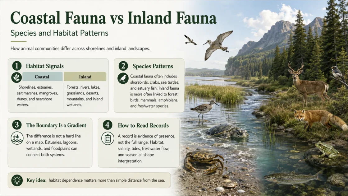
Coastal fauna and inland fauna are not separate taxonomic groups. They are animal assemblages shaped by different physical processes. Coastal assemblages are organized mainly by tides, salinity, wave exposure, shoreline substrate, marine productivity, and land–sea transitions. Inland assemblages are organized by freshwater flow, rainfall, vegetation, soil, elevation, temperature, and barriers within the landscape. The clearest contrast is therefore between habitat filters, not between two fixed lists of animals.
Formal habitat systems also treat the divide as more than distance from the shoreline. The IUCN Red List habitat scheme separates marine neritic, marine intertidal, marine coastal and supratidal, inland wetland, and terrestrial habitat classes, allowing one species to be linked to more than one system when its life cycle crosses those boundaries.[a]
The Coast–Inland Boundary Moves with Water and Landform
A straight distance band measured from the sea cannot define coastal fauna reliably. Tidal influence can extend far upriver, salt spray can shape exposed cliffs above the high-water line, and dunes can carry maritime conditions inland. Conversely, freshwater marshes, streams, forest patches, and agricultural habitats may occur close to the sea while supporting animals whose habitat requirements are essentially inland.
Distance from the Shoreline Is Not a Habitat Class
A record five kilometres from the coast may come from tidal marsh, dry scrub, freshwater swamp, upland forest, farmland, or a river corridor. Position alone cannot show which ecological process shaped the occurrence.
| Ecological signal | Coastal pattern | Inland pattern | Effect on animal communities |
|---|---|---|---|
| Water regime | Tidal flooding, waves, marine currents, estuarine mixing, and storm surge. | River flow, lake level, rainfall, groundwater, snowmelt, and seasonal flood pulses. | Determines when habitat is submerged, exposed, connected, or available for breeding and feeding. |
| Salinity | Ranges from seawater to brackish and locally hypersaline conditions. | Usually fresh water on land, but inland salt lakes and saline soils are exceptions. | Filters animals by osmoregulatory tolerance and can separate marine, estuarine, freshwater, and terrestrial assemblages across short distances. |
| Substrate | Rock, reef, mudflat, sand beach, shell bed, peat, seagrass sediment, or mangrove root systems. | Forest litter, mineral soil, river gravel, lake sediment, grassland turf, desert pavement, cave rock, or alpine scree. | Controls burrowing space, attachment surfaces, shelter, prey access, nest placement, and locomotion. |
| Vegetation | Saltmarsh plants, mangroves, dune vegetation, coastal scrub, seagrass, and algae. | Forest canopy, shrubland, grassland, savanna, riparian woodland, peatland, and alpine vegetation. | Changes food supply, vertical structure, shade, humidity, concealment, and nesting sites. |
| Connectivity | Often follows shorelines, tidal creeks, currents, estuary mouths, islands, and migratory flyways. | Often follows river networks, floodplains, mountain passes, forest corridors, seasonal wetlands, and groundwater-linked systems. | Controls dispersal, recolonization, migration, gene flow, and access to seasonal refuges. |
| Disturbance | Daily tides, wave impact, erosion, burial, storms, salt spray, and shoreline change. | Flood, drought, fire, freeze, sediment movement, grazing, and seasonal drying. | Favours different tolerances, life-history timing, body forms, and escape strategies. |
Coastal Fauna Changes Across a Narrow Sequence of Habitats
Rocky Shores and the Intertidal Zone
Intertidal animals experience repeated immersion and exposure. High-shore organisms may remain dry for long periods, while lower zones remain submerged for more of each tidal cycle. Attachment strength, resistance to water loss, tolerance of temperature swings, and the ability to shelter in crevices help structure bands of barnacles, mussels, limpets, marine snails, shore crabs, anemones, and other invertebrates. NOAA describes the high intertidal as a zone occupied by hardy animals able to withstand both wave action and long intervals out of water.[b]
This vertical zonation is a coastal pattern with no simple inland equivalent. A difference of less than a metre in shore height can change immersion time, heat exposure, feeding opportunity, and predator access enough to replace much of the local assemblage.
Estuaries, Tidal Marshes, Mangroves, and Mudflats
Estuaries combine freshwater inflow with marine tides, producing changing salinity, water depth, turbidity, oxygen conditions, and sediment deposition. These gradients create feeding and nursery areas for fish and crustaceans, shellfish beds, mudflat invertebrate communities, roosting and foraging sites for birds, and vegetated shelter in marshes, mangroves, and seagrass beds. NOAA Fisheries identifies estuaries as early-life habitat for many animals and as systems containing several linked habitat types rather than one uniform water body.[c]
Small elevation differences inside a marsh alter flooding frequency and salinity. Mudflats may hold clams, mussels, oysters, crabs, shrimp, and worms, while pools, tidal creeks, high marsh, and low marsh support different prey fields and shelter conditions. NOAA’s estuary habitat material shows that local geology and climate also change which coastal habitats occur, so an estuary bordered by mangroves cannot be treated as ecologically identical to one bordered by salt marsh or rocky shore.[d]
Beaches, Dunes, Cliffs, and Coastal Scrub
Sandy coasts are physically unstable. Waves reshape the beach, wind moves exposed sand, and salt spray reaches land above normal tides. Burrowing crustaceans, beach insects, dune spiders, reptiles, small mammals, and ground-nesting birds occupy different parts of this sequence. The strand line supplies marine carrion and plant debris; foredunes favour animals tolerant of loose sand and sparse cover; older dunes and coastal scrub support progressively more terrestrial assemblages as soils stabilize and vegetation becomes denser.
Cliffs create another pattern. Ledges may offer nesting space protected from many terrestrial predators, while adjacent waters provide food. Yet the same cliff can also contain caves, grassland, or shrub habitat used by inland-associated bats, reptiles, and insects. “Coastal” here may describe only one part of an animal’s daily movement.
Inland Fauna Divides into Rivers, Forests, Open Lands, and High Ground
Inland fauna is not a single opposite of coastal fauna. Ecoregions are separated through interacting patterns of geology, landform, soil, vegetation, climate, land use, wildlife, and hydrology. Those variables produce very different animal communities even where every site lies far from the sea.[e]
Rivers, Floodplains, Lakes, Springs, and Inland Wetlands
Inland aquatic fauna responds to flow speed, water permanence, depth, temperature, oxygen, substrate, channel form, flood timing, and connection to side channels or wetlands. Headwater streams can isolate cold-water fish and aquatic insects; floodplains open seasonal feeding and spawning habitat; lakes create depth and shoreline zones; springs can hold narrowly distributed species adapted to stable water chemistry.
Amphibians, freshwater turtles, dragonflies, mussels, crayfish, waterbirds, fish, and semi-aquatic mammals may all occur in inland waters, but not as one interchangeable assemblage. A temporary woodland pool, a fast mountain stream, a peat bog, and a deep lake impose different filters.
Forests and Wooded Mosaics
Forest fauna is structured vertically as well as horizontally. Canopy foliage, trunks, cavities, bark, dead wood, understory, leaf litter, and soil each support different animal guilds. Arboreal mammals, canopy insects, wood-boring beetles, cavity-nesting birds, forest-floor amphibians, and litter invertebrates can occupy the same mapped forest while using almost no shared microhabitat.
Moisture and temperature often change from forest edge to interior and from valley bottom to ridge. Fragment size and connection to nearby woodland can determine whether wide-ranging predators, dispersal-limited invertebrates, or interior-nesting birds remain present.
Grasslands, Shrublands, Savannas, and Deserts
Open inland systems favour animals adapted to exposure, seasonal food pulses, long sight lines, burrowing substrates, grazing, and fire. Grazing mammals, coursing predators, seed-eating rodents, ground-nesting birds, reptiles, termites, ants, and grass-feeding insects may dominate different regions. Desert assemblages add sharper limits from heat and water scarcity, often shifting activity to night, burrows, rock shade, or short wet-season windows.
Mountains, Alpine Zones, and Caves
Elevation compresses temperature, wind, snow cover, oxygen availability, vegetation, and growing season into steep gradients. Mountain animals may move vertically between seasons rather than travel toward or away from the coast. Caves impose a different set of limits: darkness, stable microclimate, restricted food input, and isolation. Both systems can produce small ranges and strong local specialization without any marine influence.
Species Patterns Differ by Animal Group
| Animal group | Common coastal pattern | Common inland pattern | Where the division breaks down |
|---|---|---|---|
| Birds | Shorebirds forage on exposed flats and beaches; seabirds feed at sea and may breed on islands or cliffs; marsh birds follow tidal vegetation and water depth. | Forest, grassland, desert, alpine, river, lake, and inland wetland birds follow vegetation structure, prey, water, and nesting habitat. | Migrants may breed inland, stop in estuaries, feed on tidal flats, and winter on the coast within one annual cycle. |
| Mammals | Marine mammals, shoreline foragers, mangrove users, and species resting or breeding on beaches and rocky coasts. | Ungulates, terrestrial carnivores, primates, rodents, bats, and semi-aquatic mammals associated with inland vegetation, caves, rivers, or seasonal water. | Wide-ranging carnivores, bats, otters, and scavengers may use coastlines without depending on them throughout the year. |
| Reptiles | Sea turtles, estuarine reptiles, saltmarsh users, and lizards or snakes associated with dunes, islands, or coastal scrub. | Freshwater turtles, forest snakes, desert lizards, river reptiles, and montane species. | Sea turtles feed and migrate in marine habitat but require terrestrial nesting beaches; some reptiles tolerate both fresh and brackish water. |
| Amphibians | Mainly associated with coastal freshwater wetlands, moist dunes, swamp margins, and a smaller set of salt-tolerant or brackish-edge habitats. | Strongly represented in inland ponds, seasonal pools, streams, cloud forests, peatlands, and moist forest floors. | Distance from the sea matters less than breeding-water salinity, hydroperiod, humidity, and access to terrestrial shelter. |
| Fish | Nearshore, reef, lagoon, tidal creek, estuarine, and saltmarsh species; many juveniles use sheltered coastal habitat. | River, lake, floodplain, spring, cave, and inland saline-water assemblages. | Diadromous species move between marine and fresh water; estuarine species may shift salinity zones with age, season, or river flow. |
| Invertebrates | Intertidal mollusks and crustaceans, reef fauna, burrowing beach animals, saltmarsh insects, and animals living on or within coastal sediments. | Freshwater insects and mollusks, soil fauna, cave animals, forest-litter communities, grassland insects, and desert arthropods. | Marine larvae may disperse by currents, winged adults may cross habitat boundaries, and soil communities can change gradually rather than at a sharp coastal line. |
Some Animals Belong to the Connection Between Coast and Interior
Sea-Run Fish Join Rivers, Estuaries, and the Ocean
Anadromous fish usually grow or mature at sea and return to fresh water to reproduce; catadromous fish follow the reverse direction. NOAA describes sea-run fish as animals that migrate among freshwater, estuarine, and marine habitats and transfer ecological effects across those systems.[f] Assigning them only to coastal fauna or only to inland fauna removes the migration route that makes their life cycle possible.
Sea Turtles Require Both Marine and Terrestrial Habitat
Sea turtles spend most of their lives in the ocean, yet adult females lay eggs on land. Feeding grounds, migratory corridors, nearshore waters, nesting beaches, dune condition, beach lighting, and access across the strand all affect different stages. NOAA notes that these turtles migrate between feeding areas and nesting beaches, sometimes across very long distances.[g] Their presence demonstrates why the shoreline is an ecological connection rather than a taxonomic wall.
Migratory Birds Shift Habitat Roles by Season
A bird may nest in tundra, forest, grassland, or an inland wetland, then use estuaries and tidal flats as stopover habitat before wintering on a coast. Another may nest on a sea cliff but forage offshore. The useful unit is therefore the habitat role—breeding, feeding, resting, moulting, or passage—not a permanent coastal or inland label applied to every record.
Species Richness Has No Universal Coastal or Inland Winner
Neither coastal nor inland fauna is globally richer in every taxonomic group or at every spatial scale. Results change with latitude, climate, habitat area, structural complexity, productivity, isolation, survey effort, and the organisms being counted. Even neighbouring coastal habitats can support different leaders: a northern Baltic study found that invertebrate diversity was highest in seagrass sediment while fish diversity was highest in sand habitat, with marked differences in community composition among rock, algae, seagrass, and bare sand.[h]
A coast-to-interior pattern can also be non-linear. A study of soil macrofauna at five distances from China’s Bohai Bay found that density, richness, and diversity rose and then fell, reaching their sampled maximum 30 kilometres from the sea. Different taxa responded differently to the gradient.[i] That result documents one regional system; it does not establish a global 30-kilometre rule.
Local Richness Peaks Cannot Be Applied Worldwide
A valid comparison needs matched area, survey effort, season, taxonomic scope, detection method, and habitat coverage. Counting seabirds and shorebirds on an accessible coast against small mammals and soil invertebrates from lightly surveyed inland habitat would compare survey design as much as fauna.
Coastal and Inland Pressures Act Through Different Networks
Coastal Habitat Can Be Compressed Between Water and Development
Coastal animals can lose habitat through wetland drainage, shoreline armouring, port and housing development, dredging, pollution, disturbance, artificial light, altered sediment supply, and sea-level rise. Tidal wetlands may normally shift landward as water levels change, but roads, seawalls, buildings, or steep terrain can block that movement. NOAA uses “coastal squeeze” for this loss of room between rising water and fixed upland barriers.[j]
The effects are not limited to resident shore animals. Loss of a marsh or estuary can remove nursery habitat for fish, stopover feeding sites for migratory birds, high-tide refuges for invertebrates, and sheltered water used during early life stages.
Inland Fragmentation Often Follows River and Landscape Barriers
Inland fauna can be separated by dams, culverts, roads, cleared land, fences, channel modification, water abstraction, groundwater decline, altered fire, and conversion of forest or grassland. In streams, even a small crossing can change flow velocity, remove natural substrate, block upstream movement, and isolate fish from seasonal refuge or spawning habitat. A USGS synthesis identifies reduced stream connectivity as a cause of fragmentation with effects on freshwater fish communities and recolonization after disturbance.[k]
The two pressure pathways meet in connected catchments. Upstream dams, sediment changes, nutrients, contaminants, and water withdrawals can alter estuaries downstream, while blocked estuary mouths can restrict animals moving between fresh and marine water. Coastal conservation that ignores the river basin, or inland conservation that stops at the tidal limit, can miss the same mobile population.
A Coastal Coordinate Does Not Prove Coastal Dependence
Occurrence records document that a taxon was reported at a place and time. They do not automatically show residency, abundance, breeding, habitat dependence, or absence from nearby systems. GBIF distinguishes checklist, occurrence, and sampling-event datasets; only the more detailed survey structures carry the effort and method information needed for many community comparisons. Its freshwater data guidance also warns that opportunistic observations cannot support the same conclusions as targeted or assemblage sampling.[l]
A defensible regional record should therefore connect the observation to habitat and behaviour. “Feeding on an intertidal flat,” “breeding in an inland seasonal pool,” “nesting on a coastal dune,” “moving through an estuary,” and “recorded from upland forest near the sea” describe different ecological relationships even when the coordinates fall within the same coastal district. Where several life stages or seasonal movements cross the boundary, the animal is better treated as multi-system or transitional than forced into one column.
Sources and Verification
- [a] IUCN Red List Habitats Classification Scheme — Used to distinguish marine, intertidal, coastal, supratidal, inland wetland, and terrestrial habitat classes.
- [b] NOAA Ocean Service: What Is the Intertidal Zone? — Used for tidal zonation, exposure, wave stress, and representative high-intertidal animals.
- [c] NOAA Fisheries: Estuary Habitat — Used for estuarine mixing, early-life habitat, and the linked habitats contained within estuary systems.
- [d] NOAA Ocean Service: Estuarine Habitats — Used for mudflat fauna, marsh zonation, and geographic variation among salt marsh, mangrove, rocky-shore, and barrier-beach estuaries.
- [e] U.S. Environmental Protection Agency: Ecoregions — Used for the interacting geology, landform, soil, vegetation, climate, wildlife, and hydrology variables that separate inland ecological regions.
- [f] NOAA Fisheries: How Sea-Run Fish Connect Ecosystems — Used for migration among freshwater, estuarine, and marine habitats.
- [g] NOAA Fisheries: Sea Turtles — Used for the marine life cycle, terrestrial nesting, and migration between feeding grounds and nesting beaches.
- [h] Henseler et al. (2019), Coastal Habitats and Benthic Community Diversity — Used for habitat-specific differences in fish and invertebrate taxonomic and trait diversity in the northern Baltic Sea.
- [i] Zheng et al. (2020), Soil Macrofauna Along a Coastal–Inland Gradient — Used for the Bohai Bay distance-gradient study and its non-linear local richness pattern.
- [j] NOAA Fisheries: The Coastal Squeeze — Used for landward wetland movement and habitat compression between rising water and fixed barriers.
- [k] U.S. Geological Survey: Effects of Culverts on Stream Habitat Connectivity — Used for inland aquatic fragmentation, movement barriers, refuge access, and recolonization effects.
- [l] GBIF Freshwater Data Publishing Guide — Used for distinctions among checklist, occurrence, and sampling-event data and the limits of opportunistic records.