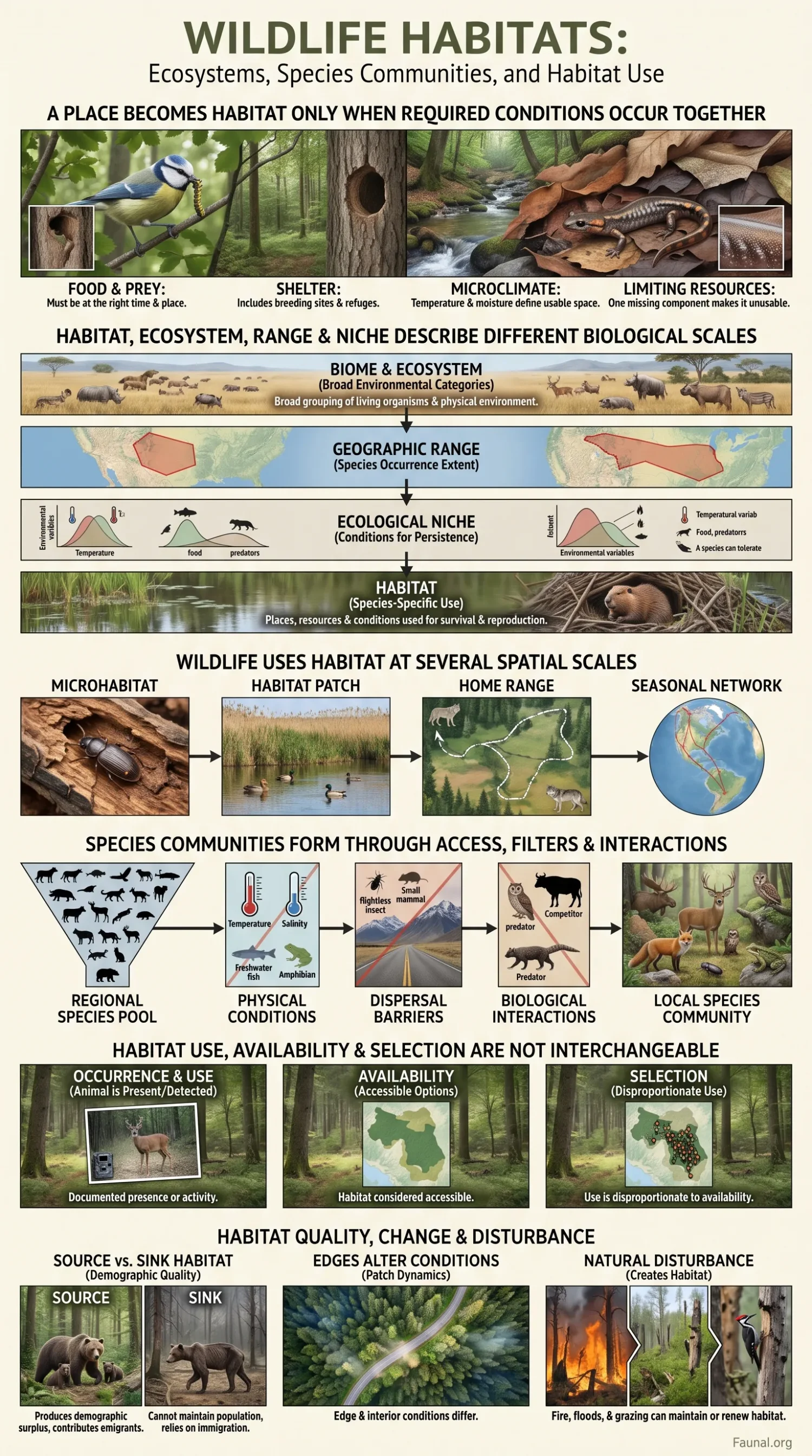
A wildlife habitat is the set of environmental conditions, resources and physical features that an animal uses to survive and reproduce. Habitat is therefore species-specific. The same forest, wetland, grassland or reef can provide suitable habitat for one species, only seasonal resources for another, and no usable habitat for a third. Food and water matter, but so do nesting sites, refuge, temperature, moisture, substrate, prey, competitors, predators, access between patches and the timing of each resource.
This species-centred meaning separates habitat from broader labels such as ecosystem or biome. A mapped forest is an ecosystem or land-cover unit before it is evidence of suitable habitat for any particular animal. Establishing habitat requires a biological question: which species, at which life stage, during which season, and for which activity?
Habitat, Ecosystem, Range and Niche Describe Different Biological Scales
Habitat terminology becomes misleading when broad environmental categories are treated as interchangeable. An ecosystem includes organisms, the physical environment and the processes connecting them. A biome groups ecosystems at a still broader level. A species range describes geographic occurrence or an estimated geographic extent. An ecological niche concerns the environmental conditions, resources and interactions under which a species can persist. Habitat focuses more directly on the places and environmental features actually used by a species.
| Concept | What it describes | Species-specific? | Does it establish habitat quality? |
|---|---|---|---|
| Habitat | Places, resources and environmental conditions used by a species for functions such as feeding, refuge, movement or reproduction. | Yes | No. Use must be separated from survival and reproductive performance. |
| Microhabitat | Fine-scale conditions or structures used within a broader habitat, such as a tree cavity, rock crevice, litter layer or shallow pool. | Usually | No |
| Ecosystem | Living organisms, the abiotic environment and ecological processes operating together. | No | No |
| Biome | A broad ecological grouping associated with recurring environmental conditions and ecosystem functions. | No | No |
| Geographic range | The geographic extent within which a taxon is recorded, mapped or inferred to occur. | Yes | No |
| Ecological niche | The conditions, resources and biological relationships associated with persistence of the species. | Yes | Not by itself |
| Land cover | A mapped description of the physical surface, such as forest, grassland, open water or cropland. | No | No |
Formal conservation datasets reflect this distinction. The IUCN Red List Habitat Classification Scheme provides standard habitat terms for taxa and is currently listed as Version 3.1. The IUCN Global Ecosystem Typology, by contrast, classifies ecosystems by their functional and compositional properties. Version 2.1 contains 25 biomes and 110 ecosystem functional groups. A species-level habitat classification and an ecosystem classification can describe the same landscape from different biological perspectives without being equivalent.
A Place Becomes Habitat Only When the Required Conditions Occur Together
The familiar requirements of food, water, shelter and space are useful starting points, but they are too broad to explain many wildlife distributions. A cavity-nesting bird does not merely require forest cover; it may need trees large enough to contain cavities, suitable food within foraging distance and a nesting period in which the cavity remains accessible and thermally suitable. A stream fish may require water but also a particular temperature range, dissolved oxygen, current velocity, substrate and an unobstructed route to spawning habitat.
Food and prey must occur at the right time and place
Food availability depends on more than whether a potential food species occurs in the area. Seeds may be available only after fruiting, insects may emerge for a short period, prey may occupy inaccessible cover, and marine prey can move with currents, temperature or tides. Habitat use can consequently shift even when the mapped habitat category remains unchanged.
Shelter includes breeding sites, refuges and resting structures
Cover is not one interchangeable resource. Nest cavities, burrows, cliffs, submerged vegetation, coarse woody debris, caves, dense shrubs and coral crevices perform different functions for different animals. A landscape can contain abundant vegetation while lacking the specific structural feature that limits breeding or refuge.
Temperature, moisture and other microclimates can define usable space
Animals experience conditions at the scale of their bodies and activity sites. A regional climate grid can hide cooler stream margins, humid leaf litter, shaded rock fissures, warm basking surfaces, insulated burrows or stable cave temperatures. These fine-scale conditions can determine when and where an animal feeds, rests, reproduces or survives an environmental extreme.
One limiting resource can make otherwise suitable habitat unusable
Habitat components are not always substitutable. A wetland may contain abundant food but dry before amphibian larvae can complete development. A forest can provide prey and cover but lack nesting cavities. A river reach can contain suitable spawning gravel yet become inaccessible behind a barrier. Habitat suitability therefore depends on the arrangement and timing of required resources, not simply the number of favorable environmental attributes.
Suitable-looking habitat can still be unusable
Broad habitat labels describe environmental settings. They do not confirm that every resource needed by a focal species is present, accessible and available during the part of the life cycle when it is required.
Wildlife Uses Habitat at Several Spatial Scales
The biologically relevant scale can range from a few centimetres to several continents. A beetle may respond to moisture inside one decaying log. A salamander may alternate between a breeding pond and terrestrial refuge around it. A large carnivore can use many vegetation types within a home range, while a migratory bird may depend on breeding, stopover and non-breeding habitats separated by thousands of kilometres.
- Microhabitat: a small physical or environmental feature such as bark, litter, a cavity, tide pool, burrow entrance or shaded stream edge.
- Habitat patch: a locally recognizable area containing a set of usable conditions, such as a reedbed, forest stand, seagrass bed or rocky outcrop.
- Home range: the broader area repeatedly used by an individual for feeding, shelter, reproduction and movement.
- Landscape or seascape: multiple habitat patches and the land or water between them, including barriers and movement routes.
- Seasonal network: geographically separated habitats linked through migration, dispersal or predictable seasonal movement.
Scale also affects analysis. A variable that explains movement within a home range may not explain where the species occurs across a continent. Recent habitat-selection research emphasizes that selection can vary among individuals, environmental settings and geographic areas rather than following one fixed response throughout a species’ range. Northrup and colleagues’ review of habitat-selection modelling treats habitat use, occurrence, availability and selection as distinct quantities, while subsequent work has documented strong individual differences in habitat associations in some populations.
Species Communities Form Through Access, Environmental Filters and Biological Interactions
A local animal community is not simply every species whose broad geographic range overlaps a place. Species must first be able to reach the site. They must then tolerate its physical conditions, obtain the resources necessary for persistence and coexist with predators, competitors, parasites, prey and mutualists. Historical events can also affect which lineages are available to colonize a region.
This sequence is often described through a regional species pool followed by dispersal and environmental or biological filtering. Research on community assembly also shows why the regional pool cannot be treated as permanently fixed: dispersal, local extinction, speciation and longer-term biogeographic history alter the species available to local communities.
Physical conditions exclude some species before competition begins
Temperature, salinity, oxygen, flow, water depth, soil moisture, substrate and light can impose physiological or mechanical limits. A freshwater animal unable to tolerate salinity cannot join an estuarine community simply because food is abundant there. An amphibian with permeable skin may be restricted by moisture conditions that have little effect on a reptile occupying the same landscape.
Dispersal determines whether suitable conditions can be reached
Islands, mountain ridges, marine channels, dams, dry valleys, roads and unsuitable land cover can separate an animal from habitat it could otherwise use. This is one reason environmental suitability cannot be converted automatically into confirmed occurrence.
Other organisms can create the habitat itself
Trees produce canopy layers, hollows, bark, dead wood and litter. Corals produce three-dimensional reef structure. Kelps and seagrasses alter flow, shelter and substrate conditions. Oysters and mussels create hard surfaces and interstitial spaces. Burrowing animals can change soils and provide shelters later used by other species. Losing a habitat-forming organism can therefore remove animal habitat even before the broad land-cover or seafloor category changes.
Habitat Use, Availability and Selection Are Not Interchangeable
Habitat use describes where an animal spends time or performs an activity. Availability describes the environmental options considered accessible to that animal. Habitat selection occurs when environmental features are used disproportionately relative to their availability. This distinction has been central to resource-selection research for decades and remains a basic requirement of modern habitat-selection analyses. Douglas Johnson’s use–availability treatment showed why the definition of what is available can alter the apparent result.
| Term | Biological meaning | What is needed to establish it |
|---|---|---|
| Occurrence | An animal is present or detected at a location. | A valid detection or other accepted record. |
| Habitat use | The animal uses a habitat unit or environmental feature. | Locations, observations or other evidence tied to the animal’s activity or presence. |
| Availability | The habitat or resource units considered accessible for potential use. | An explicitly defined spatial and temporal set of alternatives. |
| Selection | Use is disproportionate to availability. | Used and available conditions must be compared. |
| Preference | Selection under a condition in which alternatives are equally available. | Stronger assumptions than simple observation of use. |
If 70% of recorded locations fall in forest, that figure alone does not show forest selection. If forest makes up 90% of the habitat accessible to the animal, its use of forest is proportionally lower than availability.
The spatial boundary chosen for availability matters. Habitat accessible during one night’s movement differs from habitat potentially reachable during dispersal across a season. A result described as selection at one scale may disappear or reverse when availability is defined at another.
Habitat Use Changes With Season, Activity and Life Stage
A species does not necessarily have one stable habitat association. The resources needed for reproduction, juvenile development, feeding, refuge and overwintering can occur in different places. Habitat use may also change between day and night, wet and dry seasons, high and low tides, or periods of ordinary weather and environmental extremes.
- Breeding and non-breeding periods: nesting, spawning or courtship sites can differ from feeding areas used during the remainder of the year.
- Juveniles and adults: nursery habitat may provide shallower water, denser cover or different food than adult habitat.
- Day and night: shelter used during daylight can be separated from nocturnal foraging habitat.
- Wet and dry seasons: temporary water, plant growth and prey concentrations can cause large seasonal shifts.
- Tidal cycles: water depth and substrate exposure can change usable coastal habitat within hours.
- Weather extremes: thermal refuges, deep pools, snow-free areas or shaded structures may become disproportionately important during short periods.
Individuals within the same population may also differ. Sex, reproductive condition, age, social status, learning, previous experience and local environmental conditions can alter the resources selected. A pooled species-level habitat model can therefore hide narrower or contrasting individual habitat relationships.
Many Species Depend on a Network of Habitats Rather Than One Patch
Completing a life cycle may require several habitats that perform different functions. Protecting the breeding location alone may fail if the animals cannot reach feeding grounds, juvenile habitat, seasonal refuges or migratory stopovers.
- Amphibians: an aquatic breeding site may need to remain connected to terrestrial feeding and overwintering habitat.
- Migratory shorebirds: breeding and wintering areas can be linked by stopover sites used briefly for resting and refuelling.
- Anadromous fish: marine feeding habitat, river migration routes and freshwater spawning areas form one life-cycle system.
- Bats: roosts, commuting routes and feeding areas may occupy separate parts of the landscape.
Mapped continuity and functional connectivity can differ
Two habitat patches can appear close or physically connected on a map yet remain difficult for an animal to move between. The opposite can also occur: a highly mobile bird may cross a gap that isolates a flightless invertebrate. IUCN connectivity guidance treats ecological connectivity as movement of organisms and ecological processes through landscapes, freshwaters and seascapes rather than simply the visual continuity of mapped vegetation.
Corridors, riparian strips, stepping-stone wetlands, river channels and coastal routes can maintain movement where the surrounding matrix is less usable. Roads, dams, fencing, artificial lighting, intensive land use and other barriers can reduce connectivity even when suitable habitat remains on both sides.
Connectivity is species-specific
Distance between patches is not enough to determine connection. Movement ability, behaviour, mortality risk, barriers, life stage and the properties of the intervening environment determine whether the connection functions for the animal being studied.
Presence and High Use Do Not Prove High Habitat Quality
A species can occur in a place without reproducing successfully there. It may also use an area because alternatives are unavailable, because individuals are displaced from better habitat, or because environmental cues attract animals to a poor site. Habitat quality is therefore a demographic concept as well as a spatial one.
A review of habitat-quality measurement distinguishes occupancy, density and preference from measures tied more directly to demographic performance. Survival and reproduction determine whether a habitat supports population persistence, while presence alone establishes much less.
Source and sink habitats can both contain animals
In source–sink dynamics, a source population produces a demographic surplus that can contribute emigrants to other places. A sink cannot maintain itself through local reproduction and survival alone and persists through immigration. A recent review of source–sink terminology emphasizes that the classification depends on the focal species and demographic context rather than on the appearance of the habitat.
Animals can select habitat that reduces their performance
An ecological trap occurs when environmental cues lead animals to prefer habitat in which survival or reproduction is poorer than in available alternatives. Rapid environmental change can break the historical relationship between a cue and the benefit it once predicted. Research on ecological and evolutionary traps shows why preference and habitat quality cannot be assumed to move together.
High use is not a demographic quality test
Repeated detections, high occupancy or many animal locations can show that a place is being used. Demonstrating high-quality habitat requires evidence connected to survival, reproduction or population performance at the relevant scale.
Edges, Disturbance and Fragmentation Change Habitat in Different Ways
Habitat change is not one process. Removing habitat, degrading its internal condition, dividing it into isolated pieces and altering the disturbance regime can produce different biological outcomes even when the affected area is similar.
Edges alter conditions inside the remaining patch
Forest edges can differ from interiors in light, wind, temperature, humidity, vegetation structure and access for predators. Wetland margins, reef boundaries and terrestrial ecotones can likewise support assemblages that differ from adjoining interiors. Edge-associated species may gain usable space while interior specialists lose it.
Natural disturbance can produce habitat as well as remove it
Fire can maintain open vegetation in fire-adapted systems. Floods can renew floodplain channels and temporary wetlands. Treefall creates gaps and dead wood. Sediment movement forms river bars and coastal substrates. Grazing can maintain short vegetation or create structural variation at some intensities. The biological outcome depends on disturbance frequency, intensity, duration, season and the evolutionary history of the organisms involved.
Loss, degradation and fragmentation should be separated
- Habitat loss: usable area is removed or converted.
- Degradation: the broad habitat type remains but resources, structure or environmental quality deteriorate.
- Fragmentation: remaining habitat is divided into smaller or more isolated pieces.
- Homogenization: distinct structures, microhabitats or successional stages become more uniform.
- Barrier creation: animals lose access between resources or life-cycle habitats even when those areas remain intact.
These processes can interact. A road may remove little habitat by area yet create mortality and movement barriers. Selective removal of old trees may leave a site mapped as forest while eliminating cavities and dead wood. A dam can retain aquatic area upstream while interrupting longitudinal movement and changing flow, temperature and sediment downstream.
Major Habitat Systems Differ in the Conditions Animals Must Track
Broad habitat names remain useful when they are treated as environmental contexts rather than species inventories. The IUCN Global Ecosystem Typology groups ecosystems partly through the ecological processes and conditions that organize them. For wildlife, the relevant variables differ among terrestrial, freshwater, marine and subterranean systems.
| Habitat system | Conditions that often shape animal use | Fine-scale features that broad maps may miss |
|---|---|---|
| Forests and woodlands | Moisture, temperature, canopy dynamics, disturbance history and vegetation structure | Tree cavities, dead wood, bark, understory density, canopy layers and gaps |
| Grasslands and savannas | Rainfall, fire, grazing, vegetation height and seasonal plant production | Bare ground, burrows, tussocks, litter depth and short-lived wet patches |
| Deserts and semi-deserts | Water limitation, heat, rainfall pulses and large daily temperature variation | Burrows, shade, rock fissures, ephemeral pools and localized vegetation |
| Alpine and polar systems | Temperature, snow or ice duration, wind exposure and short productive seasons | Snow-free patches, cliffs, sheltered hollows, meltwater and aspect-related microclimates |
| Wetlands | Hydroperiod, water depth, flooding frequency, water chemistry and vegetation | Shallow margins, mudflats, temporary pools, emergent stems and submerged cover |
| Rivers and streams | Flow, temperature, oxygen, channel connectivity and sediment transport | Pools, riffles, gravel beds, undercut banks, woody debris and side channels |
| Lakes and ponds | Depth, temperature, oxygen, productivity and seasonal water-level change | Littoral vegetation, submerged structure, spawning substrate and thermal layers |
| Coasts and intertidal zones | Tides, salinity, wave energy, sediment and exposure | Tide pools, burrows, wrack, crevices, sandbars and narrow elevation bands |
| Reefs, kelp forests and seagrass beds | Light, depth, currents, water chemistry and persistence of habitat-forming organisms | Crevices, holdfasts, canopy layers, patch edges and nursery structure |
| Open ocean | Depth, temperature, productivity, currents, fronts and prey concentrations | Dynamic water masses, vertical layers and temporary feeding aggregations |
| Subterranean systems | Darkness, humidity, groundwater, temperature stability and nutrient inputs | Cavities, fissures, cave streams and connections to surface resources |
| Urban and modified environments | Built structure, disturbance, artificial light, food subsidies, vegetation and human activity | Buildings, drains, small vegetation patches, bridges, roof spaces and artificial water bodies |
Land Cover Is a Proxy, Not a Species-Level Habitat Diagnosis
Two areas classified as forest can differ greatly for wildlife. One may contain large old trees, cavities, dead wood, a layered canopy and native understory. Another may be an even-aged plantation with little structural variation. The mapped land-cover label is similar, but the resources available to cavity users, dead-wood insects, understory birds and other specialists can be very different.
The same problem occurs in aquatic systems. Two water bodies may share a mapped class while differing in hydroperiod, flow, salinity, oxygen, vegetation, depth or substrate. A reef footprint can remain visible after biological structure has deteriorated. A river remains a river on a map after a barrier divides previously connected habitat.
This distinction also explains why ecosystem and species-habitat datasets should not be substituted for one another. The IUCN Red List habitat scheme records major habitats associated with taxa, including information such as suitability and major importance where available. The Global Ecosystem Typology classifies ecosystem units through their ecological properties. Neither automatically establishes fine-scale habitat suitability for an individual population.
Wildlife Habitat Evidence Comes From Different Types of Observation
Habitat relationships can be studied through direct observation, repeated surveys, tracking, environmental measurements, statistical models and genetic traces. These methods answer different questions. Combining them can strengthen an assessment, but one form of evidence should not be presented as though it automatically supplies another.
| Evidence or method | What it can support | Main interpretive boundary |
|---|---|---|
| Direct field observation | Documented detection at a defined place and time; behaviour may also be recorded. | Non-detection does not automatically establish absence. |
| Camera traps | Repeated terrestrial detections, activity timing and use of monitored locations. | Detection depends on placement, field of view, trigger performance, animal movement and survey duration. |
| Acoustic monitoring | Calling, singing or echolocating animals detected within the effective sampling environment. | A sound detection does not by itself establish breeding success, local abundance or exact habitat boundaries. |
| GPS, radio or acoustic telemetry | Movement paths, repeated locations, home-range use and environmental associations of tagged animals. | Results represent the tagged sample and can vary among individuals, seasons and study periods. |
| Occupancy modelling | Probability that surveyed sites are occupied while accounting for imperfect detection. | Occupancy remains different from abundance and demographic habitat quality. |
| Resource- or habitat-selection analysis | Relative use or selection of environmental conditions compared with defined availability. | Inference depends strongly on how availability, spatial scale and sampling are defined. |
| Remote environmental layers | Land cover, vegetation structure, water, elevation, temperature and other habitat covariates over large areas. | Mapped variables can miss fine-scale structures or biological resources used by the animal. |
| Occurrence databases | Documented records contributed under stated dataset, place, time and taxonomic information. | Record density can reflect sampling effort and accessibility as well as animal occurrence. |
| Environmental DNA | Genetic evidence associated with organisms that have shed DNA into the sampled environment. | Detection of DNA is not the same as locating an individual animal or estimating local abundance. |
USGS occupancy guidance addresses a basic field problem: animals that are present are not always detected. Repeated detection/non-detection surveys can therefore be modelled to estimate occupancy while allowing detection probability to be less than one.
Animal tracking provides another evidence type. Movebank’s data model supports location estimates from GPS, radio, acoustic telemetry, geolocation and other tracking systems, together with animal and deployment metadata. These data can reveal movement and space use at high temporal resolution, but a track remains evidence from particular individuals rather than an automatic description of every member of the species.
USGS environmental-DNA guidance describes eDNA as genetic material shed into the environment and used for species detection and biodiversity monitoring. The method is particularly useful for organisms that are difficult to observe directly, but interpretation depends on sampling design, contamination control and the environmental movement or persistence of DNA.
Occurrence Points, Occupancy and Habitat Maps Carry Different Evidence
A mapped species record usually represents evidence tied to a particular place and time. It does not draw the boundary of a habitat patch, establish continuous occupancy between records or show that the whole surrounding landscape has equal value to the animal.
Absence also needs care. In ordinary occurrence data, a taxon missing from the record set cannot automatically be treated as absent. GBIF guidance for biological survey and monitoring data distinguishes explicit absence or non-detection from simple lack of a reported occurrence and notes that implicit absence requires a fully reported taxonomic scope.
An occurrence point documents a record
A reliable record can support presence at the documented location and time within the limits of its identification and coordinate quality. It does not establish local abundance, reproduction, long-term persistence or continuous distribution around the point.
Occupancy is defined by the survey unit
Occupancy models estimate use or presence within defined sites while accounting for imperfect detection. The meaning of an occupied site depends on the spatial unit, survey period and study design. A large grid cell occupied by a wide-ranging mammal and a small breeding pond occupied by an amphibian are not biologically equivalent units.
A range polygon is not continuous habitat
Broad range maps can include unsuitable mountains, cities, agricultural areas, deep water, dry valleys or other environments between occupied sites. They are useful for geographic extent but should not be converted into a claim that every location inside the boundary is occupied or suitable.
Habitat models remain dependent on scale and input data
A habitat or species-distribution model relates records or use to environmental predictors. Its apparent precision can exceed the biological resolution of the input data. Thirty-metre land-cover cells cannot reveal every tree hollow, burrow, spawning crevice or temporary pool. Models trained in one population, season or landscape may also perform poorly elsewhere when habitat relationships change with local conditions.
A mapped record is not a habitat boundary
Occurrence records document reported evidence. Habitat boundaries require additional information about environmental conditions, accessibility, spatial scale and the biological requirements of the focal species.
Changing Conditions Can Move Habitat Without Moving the Landscape
A forest, lake, estuary or mountain slope can remain in the same geographic position while the conditions that make it usable shift. Temperature, water availability, snow duration, hydroperiod, oxygen, salinity, vegetation structure, prey timing and disturbance can change without an immediate change in the broad mapped habitat label.
Climate-related shifts illustrate this problem. A cooler condition may move upslope or poleward, but the animal cannot necessarily follow it. Suitable temperature alone may not provide required vegetation, soil, prey, nesting structures or hydrology. New conditions may also lie beyond a road, agricultural matrix, dam, coastline or other barrier.
Connectivity therefore affects whether changing habitat conditions can be tracked through movement or dispersal. The ecological connection needed by a migratory ungulate, stream fish, forest amphibian and flying insect can differ sharply even within the same region.
Habitat Change Can Reorganize a Community Before Species Totals Fall
Habitat alteration does not always produce an immediate decline in the number of species counted at a site. Specialists can disappear while widespread generalists, disturbance-tolerant species or newly arriving species maintain a similar total. The identity of the community may therefore change before a simple richness count indicates a large loss.
The loss of one habitat-forming species can also propagate through the community. Removal of old trees eliminates hollows, bark structure and dead wood. Loss of coral structure removes shelter and attachment surfaces. Reduction of submerged vegetation changes nursery cover and feeding surfaces. Habitat change can therefore alter food webs and species interactions as well as the physical space occupied by animals.
Community responses are scale-dependent. A local site can gain generalist species while a region loses specialists found nowhere else within the remaining habitat mosaic. Species counts, community composition, demographic performance and habitat condition answer different ecological questions and should remain separate in wildlife assessments.
Protecting Area Alone Does Not Establish Functional Wildlife Habitat
Area is one part of habitat conservation. The biological requirement may instead be a minimum patch size, a nesting structure, a particular hydroperiod, deep-water refuge, seasonal stopover site, migration bottleneck, fire regime, intact river connection or access between feeding and breeding habitat. Conservation therefore has to match the organism, life stage, season and process being protected.
Species status and ecosystem status should also remain separate. The IUCN Red List of Ecosystems assesses the risk of ecosystem collapse using evidence about distribution, environmental degradation and disruption of ecological processes. Species assessments address extinction risk at the taxon level. An ecosystem can deteriorate while some generalist animals persist, and a threatened species can require highly specific habitat features within an ecosystem that is not itself close to collapse.
Reliable habitat interpretation therefore asks more than where an animal has been recorded. It asks what resources and conditions are used there, whether those conditions are accessible through the full life cycle, how use compares with availability, and whether the habitat supports survival and reproduction rather than presence alone.
Sources and Verification
- IUCN Red List — Habitats Classification Scheme, Version 3.1 — Used for the current taxon-oriented habitat classification and its role in describing major habitats associated with assessed taxa.
- IUCN Global Ecosystem Typology — Version 2.1 — Used for the distinction between ecosystem classification and species habitat, including the current 25-biome and 110-ecosystem-functional-group structure.
- Northrup et al. — Conceptual and methodological advances in habitat-selection modeling — Used for current terminology separating habitat use, occurrence, availability, preference and selection, and for the scale-dependent interpretation of habitat-selection analyses.
- U.S. Geological Survey — The comparison of usage and availability measurements for evaluating resource preference — Used for the use-versus-availability basis of resource selection and the effect of defining which resources are available to an animal.
- Mittelbach and Schemske — Ecological and evolutionary perspectives on community assembly — Used for regional species pools, dispersal, environmental filtering and the spatial and historical processes involved in local community assembly.
- IUCN — Guidelines for conserving connectivity through ecological networks and corridors — Used for ecological connectivity, animal movement and the role of corridors and connected habitat networks across terrestrial, freshwater and marine systems.
- Johnson — Measuring Habitat Quality: A Review — Used for the distinction between occupancy, density, preference and demographic measures of habitat quality, including reproduction and survival.
- Dias et al. — What are a source and a sink under ecological and evolutionary perspectives? — Used for species-specific source–sink interpretation, demographic surplus in source populations and dependence on immigration in sinks.
- Schlaepfer, Runge and Sherman — Ecological and evolutionary traps — Used for the mismatch between environmental cues, habitat choice and survival or reproductive outcomes after environmental change.
- U.S. Geological Survey — Occupancy models to study wildlife — Used for imperfect detection and the distinction between an animal not being detected and the surveyed site being genuinely unoccupied.
- Movebank — The Movebank data model — Used for the types of location and biologging information available from GPS, radio, acoustic and other animal-tracking systems.
- U.S. Geological Survey — Environmental DNA — Used for eDNA as shed genetic material used in biodiversity monitoring and for the interpretation limits associated with genetic detection.
- GBIF — Guide for publishing biological survey and monitoring data — Used for explicit absence, non-detection and the conditions under which missing taxa in structured survey data can or cannot support absence inference.
- IUCN Red List of Ecosystems — Used for the distinction between ecosystem collapse risk and species-level conservation assessment.
Alpine and Mountain Reptiles of Europe: Cold-Adapted Species
For Europe’s alpine and mountain reptiles, the focus is cold-adapted species, organizing the account around adaptation to the...
Alpine Mammals of Europe: Species of High Mountain Habitats
Species of high mountain habitats frame the treatment of Europe’s alpine mammals, framing the topic through the ecosystems...
Birds of Turkish Wetlands: Lakes, Deltas, and Marshes
For birds of Turkish wetlands, the focus is lakes, deltas, and marshes, keeping habitat and geographic scope together.
Coastal Fauna vs Inland Fauna: Species and Habitat Patterns
Coastal and inland fauna are compared through salinity, moisture, landforms, food webs, movement corridors, and habitat-specific animal groups.
Dams and Freshwater Fish in Turkey: Habitat Fragmentation Explained
Habitat fragmentation frames the treatment of dams and freshwater fish in Turkey, relating the species account to the...
Farmland Birds of Europe: Species Decline and Habitat Change
Europe’s farmland birds link species decline and habitat change, relating the species account to the environments named.
Forest Birds of Europe: Woodland Species and Breeding Habitats
Woodland species and breeding habitats frame the treatment of Europe’s forest birds, organizing the topic around habitat relationships.
Forest Birds of Turkey: Woodland Species and Habitats
Turkey’s forest birds are organized around woodland species and habitats, connecting species occurrence with habitat context.
Forest Mammals of Europe: Woodland Species and Habitat Use
Europe’s forest mammals are organized around woodland species and habitat use, keeping habitat use central to the species...
Forest Mammals of Turkey: Woodland Species and Records
For Turkey’s forest mammals, the focus is woodland species and records, connecting the named groups with their regional...
How Habitat Diversity Shapes Regional Fauna
Habitat diversity shapes regional fauna by creating different ecological conditions for specialists, generalists, predators, prey, and seasonal species.
Mountain Fauna vs Lowland Fauna: Main Differences
Mountain and lowland fauna differ in climate, elevation, habitat structure, seasonal conditions, and the species adapted to each...
Mountain Mammals of Turkey: Species of High Elevation Habitats
Turkey’s mountain mammals link species of high elevation habitats, connecting each setting with its wildlife context.
Terrestrial Fauna Explained: Land Animals and Their Habitats
Terrestrial fauna covers animals living mainly on land, with habitat examples ranging from forests and grasslands to deserts...
Urban Birds of Europe: Common Species in Towns and Cities
For Europe’s urban birds, common species in towns and cities are brought together, keeping the topic tied to...
Urban Fauna Explained: Animals Living in Cities
Urban fauna includes animals living in cities and built environments, with attention to habitat use, adaptation, food sources,...
Wetland Birds of Europe: Ducks, Herons, Waders, and Waterbirds
Europe’s wetland birds are described through ducks, herons, waders, and waterbirds, framing the listed species groups within the...
17 articles in Wildlife Habitat Guides