Complete guides: •Regional Fauna Guides•Birds•Fauna of Europe
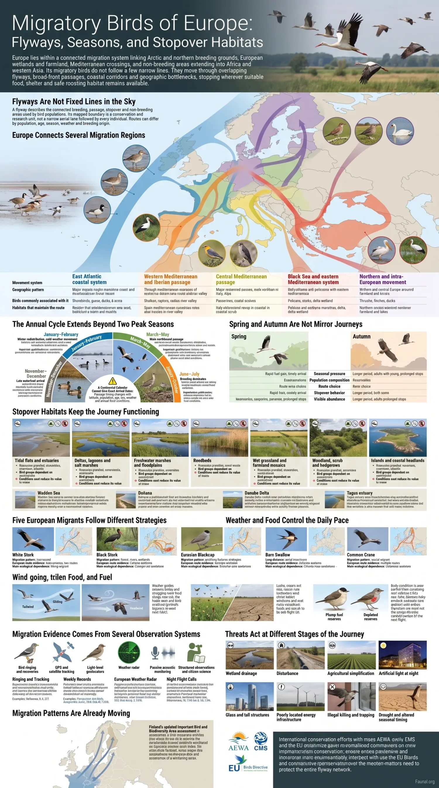
Europe lies within a connected migration system linking Arctic and northern breeding grounds, European wetlands and farmland, Mediterranean crossings, and non-breeding areas extending into Africa and western Asia. Its migratory birds do not follow a few narrow lines. They move through overlapping flyways, broad-front passages, coastal corridors and geographic bottlenecks, stopping wherever suitable food, shelter and safe roosting habitat remain available.
Flyways Are Not Fixed Lines in the Sky
A flyway describes the connected breeding, passage, stopover and non-breeding areas used by bird populations. Its mapped boundary is a conservation and research unit, not a narrow aerial lane followed by every individual. Routes can differ by population, age, season, weather and breeding origin.[a]
Europe Connects Several Migration Regions
Some birds breeding in Europe travel south of the Sahara. Others remain within Europe, move from inland areas to milder coasts, or arrive from Greenland, Arctic Canada, Scandinavia and northern Russia to spend the non-breeding season around the North Sea, Atlantic coast, Baltic Sea or Mediterranean basin. The same country may therefore hold departing summer visitors, arriving winter visitors and passage migrants at the same time.
Large conservation assessments identify broad systems such as the East Atlantic Flyway and the Black Sea–Mediterranean Flyway.[b][c] Within them are finer population routes through Iberia, Italy, the Adriatic, the Balkans, the western Black Sea and the eastern Mediterranean. These subdivisions overlap rather than meeting at exact biological borders.
| Movement system | Geographic pattern | Birds commonly associated with it | Habitats that maintain the route |
|---|---|---|---|
| East Atlantic coastal system | Arctic and northern European breeding regions through the North Sea, Atlantic coasts, Iberia and western Africa | Shorebirds, geese, ducks, terns and other coastal waterbirds | Intertidal flats, estuaries, salt marshes, coastal lagoons and undisturbed high-tide roosts |
| Western Mediterranean and Iberian passage | Western and north-western Europe through France and the Iberian Peninsula, with movement toward the Strait of Gibraltar and north-western Africa | Storks, raptors, passerines, cranes and wetland birds | River valleys, reservoirs, rice fields, marshes, wooded scrub and open feeding areas |
| Central Mediterranean passage | Central Europe through the Alpine region, Italy, Sicily, Malta and the central Mediterranean | Passerines, raptors, herons, falcons and other birds crossing or following the central Mediterranean | Po Valley wetlands, Adriatic lagoons, islands, coastal scrub and short-term emergency landing habitat |
| Black Sea and eastern Mediterranean system | Eastern and north-eastern Europe through the Danube basin, Black Sea coasts, Balkans, Bosporus and eastern Mediterranean | Soaring birds, pelicans, storks, cranes, waterfowl and passerines | Deltas, coastal lakes, floodplains, shallow wetlands, ridges and narrow land crossings |
| Northern and intra-European movement | Seasonal shifts between Scandinavia, the Baltic, inland Europe, Atlantic coasts and the Mediterranean without a trans-Saharan journey | Thrushes, finches, ducks, swans, geese and partially migratory populations | Ice-free waters, farmland, forests, urban green space, lakes and coastal feeding grounds |
Why Routes Narrow at Certain Places
Geography affects different flight styles in different ways. Large soaring birds obtain lift from rising warm air over land and often avoid long sea crossings. This concentrates them near narrow passages such as Gibraltar and the Bosporus. Small nocturnal migrants can cross open water, yet coastlines and islands still become landing areas when wind, rain or depleted fuel reserves force birds down.
Mountain ranges can divert movement toward passes, while river valleys and floodplains provide long inland corridors with repeated feeding opportunities. The Alps, Pyrenees, Carpathians and Balkan ranges therefore do not create one shared response. A crane, a swallow and a small warbler may cross or avoid the same terrain in different ways.
Broad-Front Migration Between the Bottlenecks
Many passerines migrate across a broad front rather than gathering inside one narrow corridor. They may leave northern or central Europe on parallel headings, cross the Mediterranean at many points and alter their tracks as wind conditions change. A map showing one thick arrow must therefore be understood as a continental pattern, not the documented track of every bird.
The Annual Cycle Extends Beyond Two Peak Seasons
Spring and autumn contain the largest visible movements, but migration-related relocation can occur in every month. Severe cold can displace wintering waterbirds. Failed breeders may leave nesting areas early. Adult shorebirds may begin southbound movement before juveniles, and some populations continue shifting between non-breeding sites through winter.
| Approximate period | Movement commonly visible in Europe | Important qualification |
|---|---|---|
| January–February | Winter redistribution, cold-weather movement and early northbound departure by some cranes, geese and waterbirds | Mild conditions may allow some populations to remain farther north than expected |
| March–May | Main northbound passage of many waterbirds, soaring birds, trans-Saharan passerines and aerial insectivores | Southern Europe may receive passage weeks before northern breeding regions |
| June–July | Breeding dominates, while unsuccessful breeders and some adult shorebirds begin post-breeding movement | June is not a migration-free month, especially around wetlands and northern coasts |
| August–October | Main southbound period for passerines, storks, raptors, cranes, shorebirds and many other groups | Adults and young birds may travel at different times and use different stopover patterns |
| November–December | Late waterfowl arrival, coastal redistribution and settlement in wintering areas | Storms, freezing waters and food availability can cause further movement after arrival |
A Continental Calendar Cannot Give Exact Arrival Dates
Passage timing changes with latitude, population, age, sex, weather and annual food conditions. A species recorded in southern Spain in March may not reach Scandinavia until several weeks later. Local observation dates should not be applied unchanged across Europe.
Spring and Autumn Are Not Mirror Journeys
Returning to a breeding territory can reward early arrival, while autumn movement often includes juveniles making their first migration and birds responding to a wider range of food and weather conditions. Routes, travel speed and stop duration may therefore change between seasons. Tracking of one long-distance migrant found that autumn migration lasted longer largely because many birds made a prolonged mid-journey stop.[n]
| Feature | Northbound spring movement | Southbound autumn movement |
|---|---|---|
| Seasonal pressure | Arrival timing may affect access to territories, mates and short-lived food peaks | Departure can be spread across a longer period after breeding and juvenile development |
| Population composition | Birds that survived the non-breeding season return toward breeding areas | Adults are joined by young birds completing their first migration |
| Route choice | Some populations use a faster or more direct return route | Food distribution and prevailing winds may favour a different route |
| Stopover behaviour | Rapid fuel gain may support timely arrival at breeding grounds | Some birds remain longer where food is abundant or where moult overlaps with movement |
| Visible abundance | Movement may be concentrated in a shorter passage window | Young birds and weather delays can produce a broader local passage period |
These are recurring tendencies, not rules for every species. Seabirds, waterfowl, soaring birds and small nocturnal migrants respond to different energetic demands and may show very different seasonal patterns.
Stopover Habitats Keep the Journey Functioning
Migration is divided into flight periods and time on the ground. For many species, the hours or days spent feeding between flights account for much of the total journey. Birds arriving with low fuel reserves must locate suitable food while also avoiding predators, disturbance and poor weather.
A brief resting place is often called a stopover site. A site where large numbers remain longer, build substantial fuel reserves, moult or prepare for a demanding barrier crossing may be described as a staging area. The distinction is not always exact, and one wetland may serve as a breeding area, stopover, moulting site and wintering ground for different populations.
| Habitat | Resources provided | Bird groups often dependent on it | Conditions that reduce its value |
|---|---|---|---|
| Tidal flats and estuaries | Dense invertebrate prey, shallow feeding surfaces and predictable tidal cycles | Sandpipers, plovers, godwits, knots, ducks and gulls | Loss of feeding flats, shellfish depletion, repeated disturbance and missing high-tide roosts |
| Deltas, lagoons and salt marshes | A mosaic of open water, shallow pools, mud, salt vegetation and sheltered roosts | Herons, spoonbills, pelicans, flamingos, ducks and shorebirds | Water diversion, drainage, pollution, altered salinity and development |
| Freshwater marshes and floodplains | Aquatic plants, fish, amphibians, insects, seeds and protected night roosts | Waterfowl, rails, cranes, terns, herons and reed-associated passerines | River regulation, early drainage, deep permanent water and loss of seasonal flooding |
| Reedbeds | Insects, cover from predators and communal roosting space | Swallows, wagtails, warblers, buntings and wetland birds | Uniform cutting, burning, drying and fragmented reed margins |
| Wet grassland and farmland mosaics | Seeds, waste grain, soil invertebrates and open resting areas | Geese, cranes, lapwings, golden plovers and larks | Pesticide use, removal of field margins, disturbance and rapid land-use change |
| Woodland, scrub and hedgerows | Insects, berries, shelter and protected feeding edges | Warblers, flycatchers, thrushes, chats and other passerines | Clearance, simplified planting, pesticide exposure and loss of native fruiting shrubs |
| Islands and coastal headlands | First landing habitat after a sea crossing and shelter during adverse weather | Passerines, falcons, harriers, doves and other Mediterranean migrants | Artificial light, glass, dense construction, introduced predators and human pressure |
Wadden Sea: Feeding Between Arctic and African Coasts
The Wadden Sea lies at the centre of the East Atlantic coastal system. Its intertidal flats, channels, salt marshes and sheltered roosts support birds arriving from breeding regions that include Greenland, Canada, Fennoscandia and Russia. UNESCO reports that up to 6.1 million birds may be present at one time and that an average of 10–12 million pass through annually. The site functions as a staging, moulting and wintering area rather than serving only one season.[e]
Doñana: Seasonal Water in the Western Mediterranean
Doñana occupies the Guadalquivir estuary in southern Spain and contains marshland, lagoons, dunes and scrub. Its location connects Atlantic coastal movement, Iberian inland routes and passage toward north-western Africa. UNESCO describes it as a wintering site for more than 500,000 waterfowl in suitable years.[f] The number alone does not describe the full ecological requirement: water depth, inundation timing, nearby feeding ground and undisturbed roosting space determine whether the wetland can support arriving birds.
Danube Delta: A Wetland Gateway to the Black Sea
At the meeting of the Danube and Black Sea, the Danube Delta forms a wide complex of lakes, channels, reedbeds, marshes and coastal habitats. UNESCO records more than 300 bird species in the delta.[g] Its value for migration comes from the continuity of habitat types: fish-eating birds, grazing waterfowl, reedbed passerines and shallow-water feeders can use different parts of the same wetland landscape.
The Same Estuary Can Serve Both Migration Directions
Research on Dunlins using Portugal’s Tagus estuary found that the site supported intermediate refuelling during both spring and autumn migration.[h] This illustrates why stopover protection cannot be scheduled around a single short passage event. Different populations, age classes and directions of travel may use the same feeding flats at different times.
Five European Migrants Follow Different Strategies
A species name alone does not reveal one universal migration route. Separate breeding populations may move in opposite directions, winter at different latitudes or contain both migratory and resident individuals.
| Species | Migration pattern | European route evidence | Main ecological dependence |
|---|---|---|---|
| White Stork Ciconia ciconia |
Long-distance soaring migrant with distinct western and eastern population routes | Western populations move through Iberia toward western Africa, while many central and eastern populations travel south-east through the Middle East toward eastern and southern Africa.[i] | Land-based thermal lift, narrow sea crossings, open feeding habitat and safe communal roosts |
| Black Stork Ciconia nigra |
Long-distance migrant associated more closely with forest, rivers and quiet wetlands | Western birds commonly use Iberia and Gibraltar; central and eastern birds also move through eastern Mediterranean routes. Some recent winter records occur in south-western Europe.[j] | Forested breeding areas, freshwater feeding habitat and low-disturbance stopovers |
| Eurasian Blackcap Sylvia atricapilla |
Resident, partial and long-distance strategies occur within the same species | A central European migration divide separates many south-westbound and south-eastbound populations. Birds wintering in Britain can originate from breeding areas elsewhere in Europe.[k] | Scrub, woodland edges, insects and seasonal fruit along flexible routes |
| Barn Swallow Hirundo rustica |
Long-distance aerial insectivore travelling between Europe and sub-Saharan Africa | Northbound birds appear first in southern Europe before reaching northern breeding areas later in spring; southbound departure begins while northern breeding regions are being vacated.[l] | Flying insects, open water, farmland and large reedbed roosts |
| Common Crane Grus grus |
Social migrant travelling in family groups and large flocks | European populations use several routes, including a major north-east to south-west movement toward Iberia and an eastern route toward the Black Sea, Middle East and nearby winter regions.[m] | Shallow wetland roosts combined with nearby farmland and open feeding areas |
Weather and Food Control the Daily Pace
Seasonal migration is prepared by internal biological timing and changes in day length, but the decision to leave on a particular night or day can depend on wind, rain, air pressure, temperature, body condition and the quality of the next available habitat.
Wind Can Shorten a Flight or Push Birds Away From Land
Tailwinds reduce the energy needed to cover distance. Headwinds can delay departure, increase travel cost or keep birds at a stopover. Crosswinds may produce drift, especially over water where immediate correction is difficult. Modelling of passerine migration between Europe and Africa found that wind support and access to refuelling habitat strongly affected the feasibility of south-western and south-eastern routes.[o]
Food Peaks Do Not Move at the Same Speed Across Europe
An insect-eating migrant returning from Africa may encounter spring conditions in southern Europe while its northern breeding area remains cold. As the bird moves north, local temperature and vegetation development alter insect availability. Waterbirds face a related timing problem: a wetland shown on a map may be dry, deeply flooded or disturbed when the birds arrive.
Fuel Reserves Determine the Next Possible Step
Migrating birds store energy mainly as fat. A bird reaching a poor stopover may remain longer, depart with a smaller reserve or abandon its expected route. Before crossing the Mediterranean or another area with few feeding opportunities, the amount of stored fuel can determine whether a direct crossing is possible.
Migration Evidence Comes From Several Observation Systems
No single method records every species, altitude, route and season. Modern migration research combines individual tracking, repeated observations and sensors that detect movement through the lower atmosphere.
| Method | Information produced | Main limitation |
|---|---|---|
| Bird ringing and recoveries | Connections between capture and recovery locations, migration timing, survival and long-term route change | Record density differs greatly among regions and species |
| GPS and satellite tracking | Detailed individual routes, stop duration, barrier crossings and repeated seasonal journeys | Device size, cost and sample size can limit taxonomic coverage |
| Light-level geolocators and other small tags | Broad migration routes and non-breeding regions for birds too small for many satellite devices | Location accuracy is lower and the bird may need to be recaptured |
| Weather radar | Movement density, direction, speed and altitude over wide areas, including nocturnal migration | Most radar detections cannot be assigned confidently to species |
| Passive acoustic monitoring | Species-level evidence from nocturnal flight calls | Silent species and visually similar call types remain difficult to measure |
| Structured observations and citizen science | Weekly changes in reported distribution across many countries | Observer effort and geographic coverage are uneven |
Ringing and Tracking Connect Distant Stages
The Eurasian African Bird Migration Atlas combines EURING recovery data and Movebank tracking data for 300 species.[p] It can reveal population-level divisions that disappear on a simplified continental map, but the available tracks and recoveries remain denser for some countries and species than for others.
Weekly Records Reveal Distributional Change
EuroBirdPortal combines data from national bird-recording systems. Its Migration Mapping Tool presents migratory connectivity for 50 European bird species and was developed partly to support work on avian-influenza transmission risk.[q] These maps represent reported and modelled patterns rather than a complete count of all birds in motion.
European Weather Radar Now Supports Continental Analysis
A data publication released in 2025 assembled biological measurements derived from 141 weather-radar stations in 18 European countries, covering periods between 2008 and 2023. The processed records describe density, direction and speed at different altitude layers. Radar provides broad atmospheric coverage, but the authors note that birds generally cannot be identified to species from radar alone.[r]
Night Flight Calls Add Species Evidence
A 2026 open dataset for nocturnal migration contains 13,359 annotated vocalizations from 117 Western Palearctic bird species. The recordings include time and frequency annotations that can support automated detection and studies of night migration.[s] Acoustic records complement radar by adding taxonomic information, although not every migrant calls while flying.
Migration Patterns Are Already Moving
Changes in winter temperature, ice cover, rainfall, agriculture and food supply can alter where birds stop or how far they travel. A population may shorten its migration and remain farther north, while another loses access to a wetland because drought or altered water management removes shallow feeding habitat.
Finland’s updated Important Bird and Biodiversity Area assessment illustrates the change. BirdLife reported in 2026 that Long-tailed Ducks, Tufted Ducks and Smew were wintering more often in Finnish waters, while Barnacle Geese and Tundra Bean Geese had become more dependent on Finnish stopover areas. The assessment used records from the preceding decade rather than assuming that older site boundaries still represented present bird distribution.[v]
Route Change Does Not Mean Every Bird Adapts Successfully
A shorter journey can reduce travel cost, but a new wintering or stopover area may lack legal protection, stable food supplies or safe roosts. Long-distance migrants may also be unable to adjust every stage of their annual schedule at the same rate.
Threats Act at Different Stages of the Journey
A breeding site can remain protected while the same population declines because a stopover, crossing point or non-breeding area has deteriorated. The effect depends on where the pressure occurs and how many alternative habitats remain within reach.
| Pressure | Immediate change | Possible migration effect |
|---|---|---|
| Wetland drainage and water extraction | Shallow feeding zones and seasonal pools disappear | Birds gain fuel more slowly or must travel farther before the next flight |
| Disturbance at feeding and roosting areas | Birds repeatedly take flight or abandon preferred roosts | Energy use rises while feeding time falls |
| Agricultural simplification | Insects, seeds, wet field margins and hedgerows decline | Passerines, cranes, geese and shorebirds lose inland feeding options |
| Artificial light at night | Nocturnal migrants may become attracted, displaced or disoriented | Flight paths change and collision or exhaustion risk rises |
| Glass and tall structures | Birds collide during low visibility, night attraction or concentrated passage | Mortality becomes concentrated around developed corridors and coastlines |
| Poorly located energy infrastructure | Turbines or power lines overlap with flight corridors and congregation areas | Collision, displacement or barrier effects alter route use |
| Illegal killing and trapping | Birds are removed at passage concentrations and stopover sites | Repeated losses accumulate across countries used by the same population |
| Drought and altered seasonal timing | Food peaks and water availability no longer coincide with arrival | Birds reach the next stage late or in poorer body condition |
International guidance from the Convention on Migratory Species states that artificial light can interfere with long-distance movements that form part of a species’ life cycle.[t] The problem is not confined to city centres. Ports, offshore structures, industrial areas, illuminated monuments and coastal development can all affect birds moving at night.
Illegal killing remains unevenly distributed but large in scale. BirdLife’s 2025 regional synthesis estimated that 13.1–42.7 million birds are illegally killed or taken each year across Europe, the Mediterranean, the Caucasus and the Arabian Peninsula. The estimate combines earlier regional studies and includes wide uncertainty rather than a precise annual census.[u]
Protecting a Flyway Requires More Than Isolated Reserves
A wetland reserve cannot maintain a migratory population if the next reachable feeding area has been drained or if an unprotected roost outside its boundary is repeatedly disturbed. Effective protection must retain the ecological relationship between feeding grounds, roosts, barrier crossings, breeding habitat and non-breeding areas.
The African-Eurasian Migratory Waterbird Agreement coordinates conservation of migratory waterbirds and their habitats across Africa, Europe, the Middle East, Central Asia, Greenland and the Canadian Archipelago. Its geographic scope reflects the fact that national protection covers only part of a bird’s annual route.[d]
Within the European Union, the Birds Directive protects naturally occurring wild bird species and requires habitat measures that include Special Protection Areas for listed and regularly occurring migratory birds.[w] Designation alone does not guarantee suitable migration habitat. Water levels, disturbance, surrounding farmland, coastal development and ecological connections still require active management.
The EU Nature Restoration Regulation adds a current planning process that can affect wetlands, rivers, coastal habitats and bird feeding areas. Member States are expected to submit national restoration plans to the European Commission by September 2026 and report on subsequent progress.[x] For migratory birds, the biological test will be whether restored sites hold suitable food, water and undisturbed roosts when each population reaches them.
A stopover can occupy only a small part of a bird’s annual range while determining whether it completes the next flight. The route remains functional only when enough suitable sites are available in the correct season and within the distance birds can travel on their existing fuel reserves.
Sources and Verification
- [a] BirdLife DataZone — The flyways concept can help coordinate global efforts to conserve migratory birds — Used for the definition of a flyway as a connected migration and conservation system rather than an exact flight line.
- [b] BirdLife DataZone — East Atlantic Flyway — Used to verify the recognized East Atlantic flyway scope and its migratory bird coverage.
- [c] BirdLife DataZone — Black Sea–Mediterranean Flyway — Used to verify the eastern European and Mediterranean flyway system discussed in the route section.
- [d] AEWA — Introduction to the Agreement — Used for the treaty’s geographic scope and its focus on migratory waterbirds and their habitats.
- [e] UNESCO World Heritage Centre — Wadden Sea — Used for the Wadden Sea’s staging, moulting and wintering functions and reported annual bird totals.
- [f] UNESCO World Heritage Centre — Doñana National Park — Used for the site’s habitat mosaic and reported wintering waterfowl use.
- [g] UNESCO World Heritage Centre — Danube Delta — Used for the delta’s wetland setting and documented bird-species total.
- [h] Catry et al. — Stopover Use of a Large Estuarine Wetland by Dunlins — Used for evidence that the Tagus estuary supports Dunlin refuelling during both migration directions.
- [i] Eurasian African Bird Migration Atlas — White Stork — Used for the western and eastern population routes of Ciconia ciconia.
- [j] Eurasian African Bird Migration Atlas — Black Stork — Used for migration timing, western passage and recent south-west European winter records of Ciconia nigra.
- [k] Eurasian African Bird Migration Atlas — Eurasian Blackcap — Used for the central European migratory divide and varied winter connections of Sylvia atricapilla.
- [l] Eurasian African Bird Migration Atlas — Barn Swallow — Used for the seasonal northbound and southbound movement of Hirundo rustica.
- [m] Eurasian African Bird Migration Atlas — Common Crane — Used for the principal European migration routes and seasonal movement of Grus grus.
- [n] Hedenström et al. — Seasonal Patterns and Processes of Migration — Used for tracked evidence that spring and autumn journeys can differ in duration and stopover behaviour.
- [o] Erni, Liechti and Bruderer — Wind in Passerine Autumn Migration — Used for the relationship between wind support, refuelling opportunities and Europe–Africa route feasibility.
- [p] EURING and CMS — Eurasian African Bird Migration Atlas — Used for the stated coverage of ringing recoveries and Movebank tracking data for 300 species.
- [q] EuroBirdPortal — About and Migration Mapping Tool — Used for the tool’s 50-species migration-connectivity scope and disease-management context.
- [r] Desmet et al. — Biological Data Derived from European Weather Radars — Used for the 141-station, 18-country radar coverage, measured variables and taxonomic limitations.
- [s] Airale, Pajot and Linossier — Acoustic Monitoring of Nocturnal Migratory Birds — Used for the 2026 dataset’s 13,359 annotated vocalizations and 117-species scope.
- [t] Convention on Migratory Species — International Light Pollution Guidelines — Used for the documented ways artificial light can interfere with migration and other life-cycle behaviour.
- [u] BirdLife DataZone — Illegal Killing of Birds in Europe and the Mediterranean — Used for the regional annual estimate, its geographic extent and the uncertainty range.
- [v] BirdLife International — Finland’s Updated Important Bird Areas — Used for current evidence of northward range change, wintering waterbirds and greater dependence on Finnish staging sites.
- [w] European Commission — Birds Directive — Used for the legal coverage of naturally occurring wild birds and protection of important migratory-bird habitats.
- [x] European Commission — Nature Restoration Regulation — Used for the September 2026 national restoration-plan timetable and monitoring obligations.
Related Topics
- → Birds of Europe: Species Diversity, Habitats, and Biogeographic Regions
- → Seabirds of Europe: Coastal Colonies and Marine Habitats
- → Wetland Birds of Europe: Ducks, Herons, Waders, and Waterbirds
- → Wildlife of Western Europe: Landscapes, Species, and Conservation
- → Wildlife of Eastern Europe: Forests, Wetlands, and Steppe Species
- → Wildlife of Northern Europe: Boreal Forests, Tundra, and Coasts